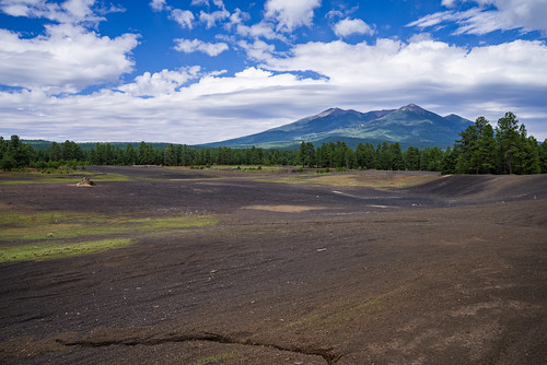
Looking for a camping spot in the woods with easy access to some of the Flagstaff area’s fantastic trails and recreation opportunities along US 180? The Wing Mountain area southwest of the San Francisco Peaks offers fantastic dispersed camping along Forest Roads (FRs) 222 and 171, suitable for tents, campers, and recreational vehicles.
Wing Mountain is a prominent cinder cone volcano located approximately six miles southwest of the San Francisco Peaks, rising to an elevation of 8,560 feet. The mountain is surrounded by ponderosa pine forest on fairly level terrain at approximately 7,600 feet.
- FR 222 and FR 171: Easy to navigate, with fairly smooth, wide dirt roads offering areas where you may pull your vehicle and rig up to 300 feet off the road (refered to as “camping corridors” on the Motor Vehicle Use Map).
- Western end of FR 222A (between FR 171 and FR 519): Easy to navigate and offers areas suitable for everything from tents to recreational vehicles. Warning: there is a section of FR 222A that requires high clearance and four wheel drive where it crosses a burned section of forest.
- Northern end of FR 222A (near FR 222) and western end of FR 9001P (near FR 171): These roads are narrower and rougher, and more suited to tent or small trailer camping.
Nearby Attractions and Activities
Distances and estimated driving times from the junction of US 180 and Forest Road 222:
- Arizona Snowbowl: 8 miles, 16 minutes
- Humphreys, Aspen Loop, and Kachina trailheads (at the Snowbowl): 8 miles, 16 minutes
- Kendrick Park Watchable Wildlife Trail: 11.5 miles, 13 minutes
- Bismarck Lake Trail: 13.5 miles, 22 minutes
- Arizona Nordic Village: 7.8 miles, 10 minutes
- Red Mountain Trail: 23 miles, 27 minutes
- Slate Mountain Trail: 24 miles, 40 minutes
- Lava River Cave: 10.5 miles, 20 (via FR 245) to 30 minutes (via FR 222)
Directions
- Flagstaff to Forest Road 222 via US 180 (map): Drive north on US 180 for 8.7 miles. Turn left on FR 222 (1.3 miles past Snowbowl Road). The dispersed camping area begins here and extends most of FR 222 (6.5 miles), and along FR 171 between FR 222 and FR 222A (to the south).
- Flagstaff to Forest Road 171 via I-40 (map): Drive east on I-40 for 10 miles from the I-17/I-40 interchange. Take exit 185 toward Belmont. Turn right onto Transwestern Road, then left on Brannigan Park Road. Drive for 0.8 miles and turn right onto Forest Road 171. Drive 1.1 mile to the southern end of the dispersed camping area at the junction of FR 171 and FR 222A. The dispersed camping area extends up FR 171 for two miles to FR 222, and most of the lenghth of FR 222.
There are also additional dispersed camping corridors along FR 171 north of FR 222 in the Lava River Cave area.
Click on map thumbnail to open a larger view in a new window [PDF, 4.2 MB]:
GPS Coordinates
Latitude 35° 16′ 10.2828″ N
Longitude 111° 44′ 33.9576″ W


