Closure Notice: (posted 3-27-2020)
In accordance with guidance from the Centers for Disease Control and Prevention and with the Governor’s shelter in place order, the BLM will temporarily close this site until further notice to help limit the spread of COVID-19.
For a list of closures please visit our COVID-19 Update page
Overview
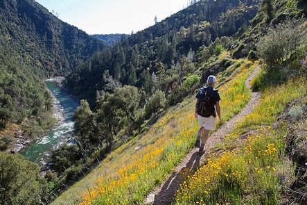
The Stevens Trail is a popular year-round hiking trail in the lower elevations of the Sierra Nevada mountain range. Historically, the trail connected the town of Iowa Hill with the city of Colfax, both in Placer County, California. The current trail extends 4.5 miles along the northwestern slope of the North Fork of the American River Canyon. It begins at the trailhead in Colfax and ends at the confluence of Secret Ravine and the North Fork of the American River.
From the present parking area at the headwaters of Slaughter Ravine near Colfax, the trail heads north and gradually down slopes in elevation. From there, it turns east beneath the renowned Central Pacific Railroad, Cape Horn, crossing Robbers Ravine, and finally ends at Secret Ravine.
While on your journey you will enjoy a series of spectacular views of the famous Gold Rush era river, pass the infamous China Wall built by Chinese laborers, several mine shafts, and other early signs of mining. Please stay out of mines as they are unstable and extremely dangerous.
During the months of April and May, you will be treated to a beautiful wildflower display. Dogwoods and redbud represent the larger flowering plants, while baby blue eyes, shooting stars, monkey flowers, lupines and tiger lily brighten the lower plant canopies.
Trail History
The story of the Stevens Trail begins with the establishment of the Gold Rush mining communities of Illinoistown and Iowa Hill, separated by the steep North Fork American River canyon. The Stevens Trail was originally surveyed under the ownership and direction of John Rutherford, an Iowa Hill miner and tanner. Rutherford soon brought in a partner, Truman A. Stevens, also a miner. Stevens was responsible for the completion and actual use of the trail during its main years of historic use, 1870-1895.
The trail was originally used as a toll path from Colfax down to Secret Ravine along the American River and then traveled up the other side to Iowa Hill which was a major metropolis during the Gold Rush period. Eventually, the use of the trail died down as did gold fever and it was all but forgotten until 1969 when a Sacramento area Boy Scout was credited with rediscovering the trail. Although the bridge connecting the two sides of the river no longer stands, the trail still provides a beautiful hike through an area that was once bustling with miners…all in search of gold! The Stevens Trail is now listed on the National Register of Historic Places.
Hunting and Shooting Info – Stevens Trail
- All public lands located in MDM, T. 15 N., R. 9 E., Sec. 26 are CLOSED to target shooting.
- Hunting is allowed, in accordance with State law, unless a specific area is signed CLOSED by the BLM.
NOTE: All California game species are regulated by the California Department of Fish and Wildlife (CDFW).
Rules, regulations, and seasons are controlled by CDFW, and it is the hunter’s responsibility to verify and
comply with proper species, seasons, zones, regulations, and legal location if hunting on public lands.
FGC
3004 – It is unlawful for any person to hunt or discharge while hunting, any firearm or other deadly weapon within
150 yards of any occupied dwelling house, residence, or other building or any barn or other outbuilding used in
connection therewith. The 150 yard area is a “Safety Zone.”
Helpful Links:
Where to Shoot
California Department of Fish & Wildlife
Hunting,
Fishing and Recreational Shooting on Public Lands, BLM California
Please also visit our webpage for:
North Fork
American River
Return To: BLM, Mother
Lode Field Office
Gallery
Directions
Follow I-80 East towards the town of Colfax and exit at North Canyon Way. Travel along North Canyon Way for about a mile. Go past the Colfax cemetery to the Stevens trailhead. Parking will be on your left.
Please Note: Due to increased use of the Stevens Trail, on weekends and in the high use season, parking can be a problem. When parking along North Canon Way, be sure to legally park alongside the road safely out of the traffic. Do not block driveways and please respect private property rights. Vehicles parked illegally on private property or blocking any driveway will be towed at the owners expense.
GPS Coordinates
Latitude 39° 6′ 19.9620″ N
Longitude 120° 56′ 49.4988″ W