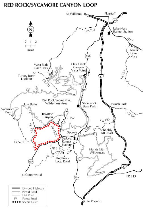
This drive takes you into the heart of the magnificent Sedona Red Rock Country. The route hugs to the foot of those colorful cliffs and offers the option of four scenic side trips that lead to some of the most exciting features in Red Rock Country.
The Sterling Canyon Spur leads to two of the most spectacular rock formations in the area. Devil’s Bridge and Vultee Arch are each just a short hike off the road. The Boynton Canyon Spur leads to a trail into an area described as one of Sedona’s energy vortexes. The Loy Butte spur will put you in the middle of some of the area’s more sweeping vistas. The Sycamore Canyon Spur takes you past Robber’s Roost, where horse thieves once hid their contraband, and to Sycamore Pass, the gateway to the Sycamore Canyon Wilderness. Visiting every place on this list should put you at Red Rock Crossing at just about sunset. There, you can enjoy a bit of refreshment at one of the picnic tables before you join the chorus of photographers there to record one of the world’s most photographed scenes.
Length: About 23 miles, not counting spurs.
Season: All year although unpaved sections of the route may become muddy after storms.
Attractions: Red rocks galore, picnicking (primitive), hiking, biking, wildlife watching, photography
Driving Time: All day for the entire loop, but you may want to split it up into more manageable segments.
Note:
- FR152C is now paved about one-half mile beyond the Doe/Bear Mountain trailheads, and the Red Rock Loop Road is paved except for the last mile or so. The rest of this route is unpaved and can become muddy and slippery when wet.
- The Vultee Arch Spur (FR 152, Vultee Arch Road) is extremely rough. A high clearance vehicle is highly recommended. There is a large trailhead parking area near the beginning (paved portion) of the road. Devil’s Bridge is about a 1.5 mile hike from here (Chuckwagon Trail to Devil’s Bridge Trail).
Directions
Location: From Flagstaff drive south 29 miles on US 89A through Sedona to Dry Creek Road (FR 152C). Turn north and proceed along FR 152C for 2 miles to the Vultee Arch road and another 2.5 miles to the intersection with Boynton Canyon Road. FR 152C continues southwest left onto an unpaved road. In about 4 miles, FR 152C intersects FR 525. From here you can turn north (right) to the Loy Butte spur or south (left) to continue the drive. In another 4 miles FR 525 intersects FR 525C (Sycamore Pass spur). This road will take you to the East side of Sycamore Canyon. Continue south 5.5 miles to US 89A and another 5.3 miles on pavement back to Sedona. The Red Rock Loop Road (see photo), which accesses Red Rock Crossing and the Verde River, is located off US 89A about one mile south of Sedona.
Click map graphic for PRINTABLE view.
GPS Coordinates
Latitude 0° 0′ 0.0000″ S
Longitude 0° 0′ 0.0000″ W

