N/A
Directions
GPS Coordinates
Latitude 0° 0′ 0.0000″ S
Longitude 0° 0′ 0.0000″ W
N/A
Latitude 0° 0′ 0.0000″ S
Longitude 0° 0′ 0.0000″ W
This campground lies on the south shore of the Middle Fork Feather River on Forest route 22N62 at the confluence of the Little North Fork of the Middle Fork Feather River and South Branch Feather River. Access is via Brush Creek or Mountain Spring House off Lumpkin Ridge Road. The facility has no water or garbage collection. Pack it in, pack it out for your trash. Road access is not recommended for RVs and trailers. A vault toilet, dedicated campsites, and fire rings are provided. Campfires are prohibited when fire restrictions are in effect. Propane or white gas stoves and lanterns are permitted during fire restrictions with a valid California campfire permit.
Please respect closed areas for protection of natural resources.
Latitude 39° 42′ 21.6000″ N
Longitude 121° 16′ 4.8000″ W
Remains open through the winter season — no snow plow or other services.
One of Mt. Hough Ranger District’s “non-fee” campgrounds, Deanes Valley Campground is located 4 miles SW of Quincy, off of Bucks Lake Rd. in the Meadow Valley area. A few sites are creekside, with a total of 7 campsites that operate on a “first come-first serve” basis. There is a vault toilet, but no piped water. The campground accommodates both tents and trailers.
Latitude 39° 52′ 48.0000″ N
Longitude 121° 1′ 19.2000″ W
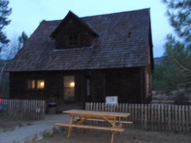
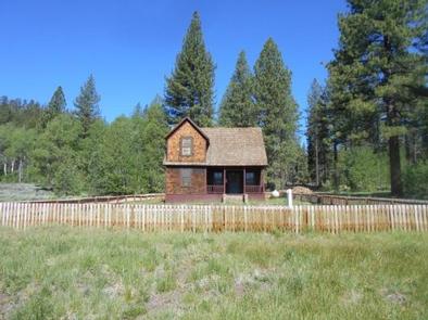
Crocker Guard Station was built in 1912 as a home for Forest Service personnel, and was later staffed as a fire station until the 1980s. The historic Crocker Guard Station is located ten miles northeast of Portola, California, at an elevation of 5,700 feet. Visitors will experience the beautiful solitude of the Eastern Sierra Nevada Mountains. Nearby recreational opportunities include fishing, boating, swimming and hiking.
Crocker Campground is located adjacent to the Crocker Guard Station. This ten unit campground is free of charge and has tables, fire rings and vault toilets. The campground is the perfect place to expand your guest list or have a campfire. Lake Davis Recreation Area is within three miles, offering a variety of recreational opportunities where visitors can fish, boat, swim, bike and hike. Hunting is a popular activity in the fall.
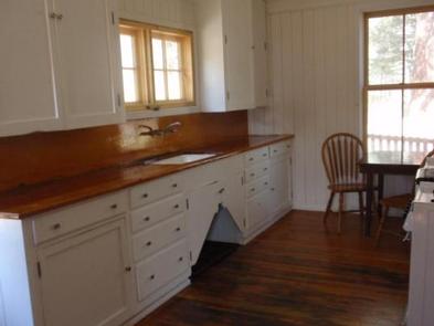
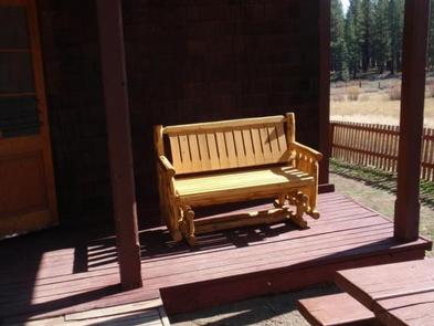
The house has four bedrooms with ten twin beds and mattresses including two sets of bunk beds, a kitchen, dining room, living room and an outside vault toilet building. Children will enjoy the large fenced in front yard. The rental has propane operated lights, cook stove and heater. There is no refrigerator. Cooking and eating utensils are provided. The house is equipped with smoke and carbon monoxide detectors and fire extinguishers. Visitors must bring drinking water. There is an outside hand pump with water for fire protection. Guests should bring bedding, towels, flashlights, trash bags and first aid kits. Visitors are responsible for cleaning the house, packing out trash and locking up before departure.
The Guard Station is situated in a small meadow near an aspen grove surrounded by a forest of pine trees.
Stores, services and restaurants are available just ten miles away, in Portola, CA.
The largest railroad museum in the west is located in Portola. It has a gift shop, train rides and plenty of railroading information
Water activities like boating and fishing are as close as Lake Davis just five miles away on a dirt road.
The nigh time sky offers star gazing, golden moon rises and meteor showers away from bright lights. There is some light pollution from Reno.

From Portola, CA, travel east on Highway 70 for five miles to Beckwourth, CA. Travel north on County Road 111 (Beckwourth-Genesee Road) for six miles. Crocker Guard Station is on the left.
Latitude 39° 53′ 36.7199″ N
Longitude 120° 25′ 25.2599″ W
Wyandotte Campground is located within 5 miles of the town of La Porte, CA on the Feather River Ranger District. At an elevation of 5100 feet, the campground is nestled in a natural mixed-conifer forest environment. Little Grass Valley reservoir is a 1600 ac., clear mountain lake with plenty of summer and winter recreation opportunities available.
Little Grass Valley Reservoir part of a larger network of streams, rivers, and reservoirs that link features of the South Fork Feather River system with Lake Oroville. Scenic vistas, watchable wildlife, and historic mining sites are in immediate or close proximity to the facility. Operations are seasonal due to winter snow, and delayed openings may result from late snow.
There is plentiful wildlife including bear, deer, squirrel, songbirds, bald eagle and osprey.
Activities at the facility include camping, power and flatwater boating, swimming, fishing, hiking, wildlife watching, scenery viewing, and historic sites.
Take the La Porte-Quincy Rd. from Brownsville or Quincy-Hwy 70 to the town of La Porte, CA. Travel 3 miles NE of town to the So Fork Rd. or Little Grass Valley Rd.
Latitude 39° 44′ 42.0000″ N
Longitude 120° 59′ 15.0000″ W
Little Beaver Campground is located on the south-eastern shore of Little Grass Valley Reservoir, approximately four miles from the town of La Porte, CA. This campground is the largest campground at the reservoir and is adjacent to a swimming beach, boat launch ramp, amphitheater, and Lakeshore Trail.
Little Grass Valley Recreation Area offers opportunities for many recreation experiences. Three boat launch ramps provide access to the water for fishing, water-skiing, sailing, or simply touring on boats. There is a wheel chair accessible fishing ramp at the dam. Two beaches provide excellent swimming and picnicking opportunities – one of which is located adjacent to the Little Beaver Campground. The Lakeshore Trail (13.5 miles) winds around the entire lake and is open for hiking, horseback riding and mountain biking. Additional hiking trails abound in the area and include the nearby Pacific Crest Trail. Visitors may also enjoy watching wildlife, campfire programs, or exploring nearby historic gold mining towns.
The facility offers 120 campsites, flush toilets, and drinking water. Each campsite has a picnic table and campfire ring. For RVs, a dump station and drinking water are available within one mile. For visitors wanting to experience the lake first-hand, a boat launch and beach day-use area are adjacent to the facility.
Located along a beautiful lakeshore and forested setting near a year-round creek, the area offers scenic views of the lake and Bald Mountain. Surrounding the facility, visitors may observe such wildlife as Osprey, bald eagles and other species of birds along with deer, bear, fisher and other mammals. Interesting geologic formations are also nearby.
History buffs will enjoy the area’s old mining sites, towns and cemeteries — all within 10 miles for exploration and discovery. The town of La Porte is within four miles and has restaurants, groceries and gasoline.
Premium Lakeside sites are $25/site per night.
Take the La Porte-Quincy Rd. west from SR70, or travel east on La Porte Rd. from Brownsville. Travel to the intersection of the La Porte-Quincy Rd. with Little Grass Valley Rd. and follow the signs toward the lake. Turn right on to Old Little Grass Valley Rd. and travel approximately 2 1/2 miles to the turn-off to Little Beaver Campground and Maidu Boat Launch.
Latitude 39° 44′ 42.0000″ N
Longitude 120° 59′ 15.0000″ W
California Wilderness Act
The Bucks Lake Wilderness was established by the California Wilderness Act of 1984. The wilderness encompasses 21,000 acres, and is located near the northern end of the Sierra Nevada mountain range.
Topography
Elevations in the Bucks Lake Wilderness range from 2,000 ft. in the Feather River Canyon to 7,017 ft. at Spanish Peak. The top of the escarpment which the Pacific Crest Trail (PCT) crosses unfolds a spectacular view of the forest to the east and north. An impressive view of Mt. Lassen is visible on clear days.
The Bucks Lake Wilderness has a broad diversity of topography and vegetation. Ground cover varies from brush fields to conifer stands, oaks and pure red fir stands. Several small lakes are scattered across the eastern portion of the Wilderness. Along the western slope are small meadows and quaking bogs hidden among the dense stands of red fir.
Latitude 39° 56′ 38.4000″ N
Longitude 121° 12′ 0.0000″ W
United States Forest Service will be taking over Sly Creek Recreation Area in 2018. Sly Creek Campground has 25 units. Campground has drinking water, rest rooms,and garbage service. Each camping unit has a table and a fire ring.Trailers up to 22 feet can be accommodated, however no hookups are provided. Maximum stay is 14 days.Sly Creek Reservoir usually opens around May 4 through October. Boat ramp open.
Latitude 39° 35′ 27.6000″ N
Longitude 121° 6′ 28.8000″ W
Creekside campsites; 6 units total for both tent and RV camping.
Latitude 39° 54′ 3.6072″ N
Longitude 121° 1′ 25.8420″ W
Granite GapTrailhead junction is marked by a sign on Gold Lake Trail. Trail Length – .9 miles
Difficulty – Easy, steep.
Approximate hiking time – 30 minutes
Accesses Mud Lake, Rock Lake, and the PCT, where Granite Gap terminates. Campsites at Mud Lake; limited sites at Rock Lake.
Open for hiking. Beautiful wildflowers – penstemon, larkspur, steer’s head and fawn lillies. (07/13/10)
Latitude 0° 0′ 0.0000″ S
Longitude 0° 0′ 0.0000″ W