Whether on foot or bike, Trinity River Management Unit (TRMU) carries you into a world of Pacific madrone, ponderosa pine, Douglas fir and white oak, which line small streams and surround deep lakes penetrated by granite domes.
There are a number of trail experiences on the TRMU. Trailblazers can choose any where between a scenic, quarter-mile hike to Backbone Creek (particularly colorful in autumn) to a 19-mile+ backcountry mountain excursion that continues through an extensive forest trail system. Big and Little Boulder Lake Trail is an easy and rewarding two mile hike leading to sights of impressive granite walls, deep blue waters, conifer forests and showy wildflowers. Hobo Gulch to Grizzly Lake Trail is for the experienced hiker; trail affords views of a large alpine lake and a 70-foot waterfall. A popular choice is Stuart Fork Trail that starts from Bridge Camp Campground. The trail has very little elevation variation, good fishing opportunities and the option of continuing 15 miles to Sapphire Lake.
Mountain biking is a popular pastime on the TRMU. Several trails afford experiences for the novice and experienced biker. Some trails are moderately strenuous requiring the rider and bike to be in fairly good shape. The scenic vistas are worth the effort: Trinity Alps, Trinity Divide and Trinity Lake. A great mountain bike ride for people of all experience levels is along the Minersville Trail that parallels the shoreline of Trinity Lake.
Anglers will find cold, clear running streams on the unit providing excellent catches of steelhead, silver salmon and Chinook salmon in the Trinity River and native rainbow trout in tributary creeks and streams.
The Trinity Heritage National Scenic Byway is a great introduction to the scenic beauty, rich history, diverse peoples and resource management activities of the area. There is a free self guided auto tour brochure, "Trinity Heritage Scenic Byway" available through the Weaverville Ranger Station, P.O. Box 1190, Weaverville, Ca 96093 (530) -623-2121. This brochure leads you through a driving tour of 17 stops along this scenic byway. Each stop provides an opportunity for you to get out of your car, stretch and get a closer look at some of the fascinating points of interest.
The second largest wilderness area in California, the Trinity Alps Wilderness nearly doubled in size by the 1984 California Wilderness Act. In that same year, it was added to the National Wilderness Preservation System. It currently has over 600 miles of trails and embraces over 500,000 acres of land.
Chiseled granite peaks and alpine lakes dot the Trinity Alps Wilderness, with elevations from 2,000 feet in creek drainages to 9,000 feet at summits. This wilderness offers many different trails ranging from 1.5 miles to 15 miles at varying levels of difficulty.
Management of the Wilderness is shared by the Shasta-Trinity National Forest, Klamath National Forest, Six Rivers National Forest and the Bureau of Land Management. Information about this wilderness can be found at wilderness.net, a website jointly managed by the University of Montana and the four federal agencies that manage Wilderness.
Trinity Alps Frequently Asked Questions (Update in progress, call 530 623-2121 for information)
Preacher Meadow campground is located one mile south of Trinity Center off of Highway 3 and approximately 30 miles from Weaverville.
This quiet and serene campground attracts hikers as it is near the popular Swift Creek trailhead and many persons stay there before and after their hikes. The campground has two large unnamed loops meandering through mature cedar, ponderosa pine and some deciduous trees. The middle story is comprised mostly of deciduous trees providing fair privacy between campsites. The understory is grass and pine needles. Some parking aprons are overgrown. State Route. 3 traffic noise can be heard in campground. While there are no grilles, each campsite has a Klamath Oven, stone fire ring, table, paved road and unsurfaced spurs and drinking water.
Nearby Activities
Camping
Directions
From Weaverville, take Hwy 3 north for 27 miles. Turn left at the campground sign. Campground is 1/2 mile from the turnoff.
Cooper Gulch Day Use area is located 19 mile east of Weaverville, 4 miles north of Lewiston on Lewiston Lake and is situated on the water's edge and is a favorite spot for anglers. This facility is fully wheelchair accessible.
Located 17 miles from Weaverville, north on Hwy 3. The boat ramp is useable until the water reaches 46 feet drawdown and has a courtesy dock. There is an accessible flush restroom at the swim beach/picnic area and a drinking fountain.
Located off of State Route 3 on the Stuart Fork arm of Trinity Lake. There is one group picnic site and several other single sites, all with a table and pedestal grill. The picnic area is next to the beach. There is a drinking fountain. The swim beach is in an area where children and adults can swim as long as the water is within 40 feet of the high water line. It has a very gradual slope for young swimmers. The swim area is marked and a very popular place for families from the adjacent campgrounds and the community. There is a fee for the use of this area.
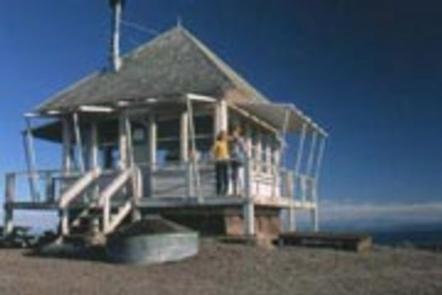
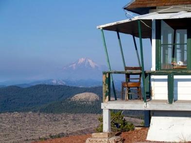
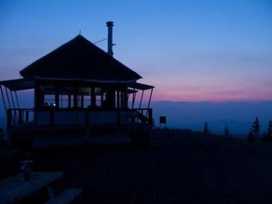
Little Mt. Hoffman Lookout was constructed in the 1920s and was used by the Forest Service on a regular basis until 1978. It is one of the few remaining historic lookouts in the Shasta-Trinity National Forest and is eligible for listing on the National Register of Historic Places. The lookout is still used by the Forest Service in times of extreme fire danger.
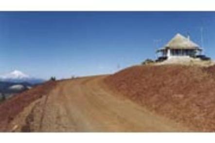
The lookout is accessible by car, but the last 4 miles are on unpaved roads and difficult for RVs and cars with trailers to navigate. Visitors must bring many of their own supplies. The accommodations of this lookout may be rustic, but the views guarantee that visitors will have a memorable stay.
Recreation
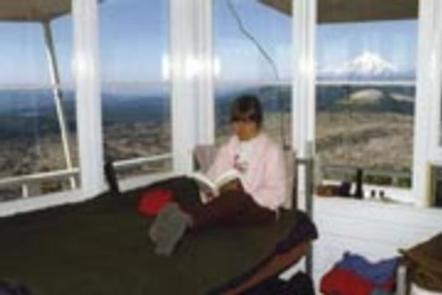
Little Mt. Hoffman Lookout is an ideal location for sightseeing and bird watching, and it’s a photographer’s dream. Visitors in search of more active pursuits can drive a short distance to hike and explore the many nearby hills, clearings and caves. Medicine Lake has a day use area with a large swim beach and a boat dock.
Facilities
The lookout is a 14×14 wooden cabin that sits on the ground. Front steps lead up to the entrance and a wooden deck surrounds it. It’s equipped with a wood stove, two cots, a shovel, a bucket, storage cabinets, dining table, cleaning gear and a fire extinguisher. A barbecue pit and picnic table are located outside. A vault toilet is housed in a separate building. This facility houses a maximum of four people.
The lookout has no cooking facilities, water, bedding or electricity. Visitors must bring their own water supply and garbage bags to pack out their trash. Recommended supplies include food, toilet paper, linens and blankets, firewood, cooking utensils, extra batteries and a flashlight or lantern. Visitors should also remember to bring the reservation confirmation and the lock combination. The use of portable stoves using gas, jellied petroleum or pressurized liquid fuel is allowed with a valid California campfire permit (click here for more details on Little Mt. Hoffman Lookout).
Natural Features
Little Mt. Hoffman is a cinder cone on the flanks of Medicine Lake Highland, the largest identified volcano within California, which extends roughly 15 miles east to west and 25 miles north to south. Medicine Lake Highland has a caldera that is partially filled by Medicine Lake. Little Mt. Hoffman sits on the rim of this caldera at 7,309 feet, providing a panoramic view of this diverse volcanic landscape.
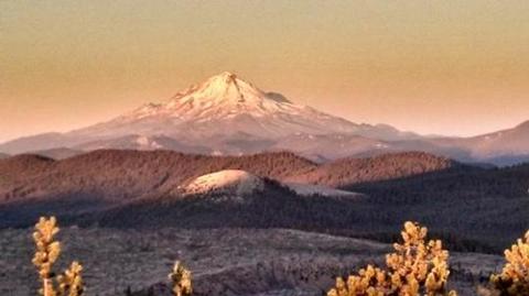
Visitors can see a spectacular view of Mt. Shasta, Mt. Lassen and southern Oregon’s Mt. McLoughlin. The panorama includes the Tulelake Basin to the north, the Fall River Valley in the east and the Medicine Lake Highlands to the south.
Charges & Cancellations
A $10.00 service fee will apply if you change or cancel your reservation. Late cancellations are subject to additional fees. For full details see NRRS Reservation Policy .
Nearby Activities
Biking
Historic & cultural site
Camping
Hiking
Hunting
Wildlife viewing
Gallery
Directions
From McCloud, California, travel east on Highway 89 for 16 miles to Road 15 (the Harris Springs
Rd). Turn left and travel on a paved road for about 4.5 miles on Road
15 to the 49 road (Powder Hill Road). Travel for approximately 28 miles
northeast to the Medicine Lake area. From there, follow the road along
the north side of Medicine Lake for approximately 4 miles to Little Mt.
Hoffman. These last 4 miles are not paved and motor homes and vehicles
pulling trailers are not recommended.