Categories
Uncategorized

Goose Island Group Sites

Overview

The two sites at Goose Island are ideal for groups wishing to be close to the town of Moab and Arches National Park. The area offers outdoor enthusiasts many options for hiking, mountain biking, whitewater rafting, and four-wheel drive tours. The town of Moab is 10 minutes away and has dining, shopping, sports rentals, tour companies and museums.

Recreation

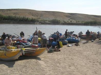
From Goose Island Campground, a paved bicycle trail leads to Arches National Park, the Bar M Mountain Bike Trailhead, the town of Moab, or up State Route (SR) 128 along the Colorado River. Arches and Canyonlands National Parks are nearby and have many scenic overlooks, hiking trails, and four-wheel drive roads. The SR 128 river corridor is filled with red rock canyons, hiking and equestrian trails, river access and activites, and scenic vistas.

Facilities

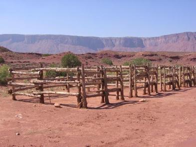
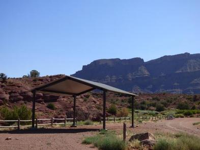
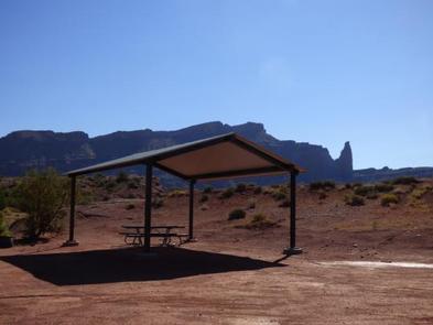
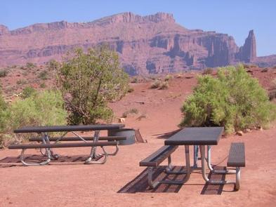
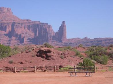
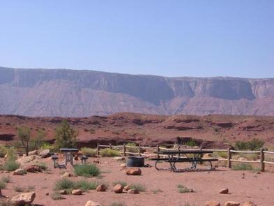
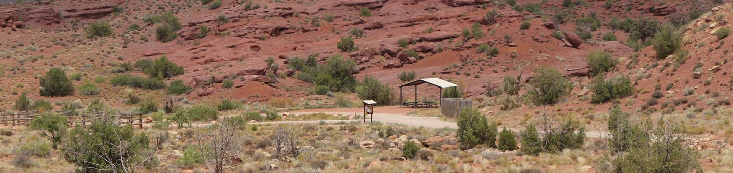
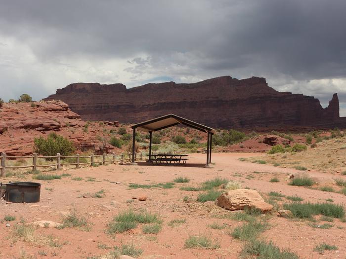
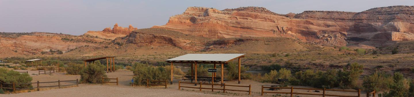
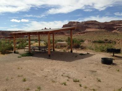
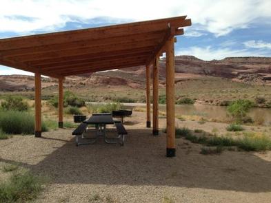
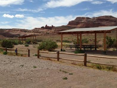
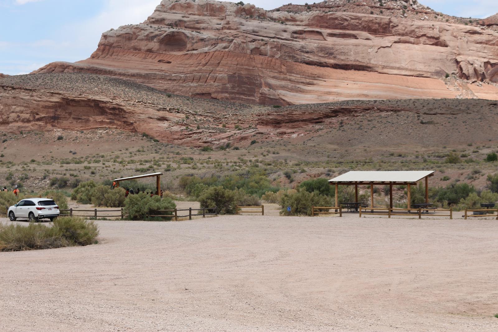
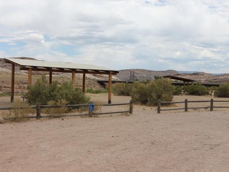
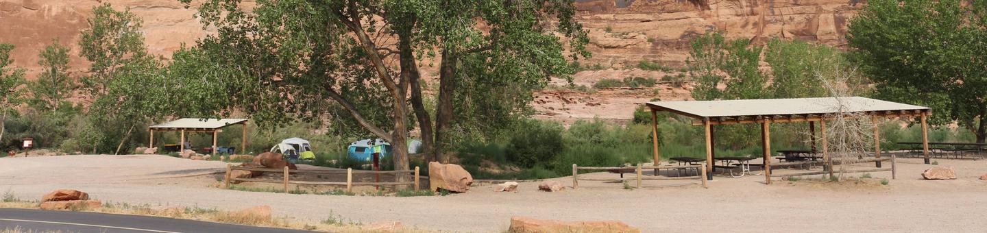
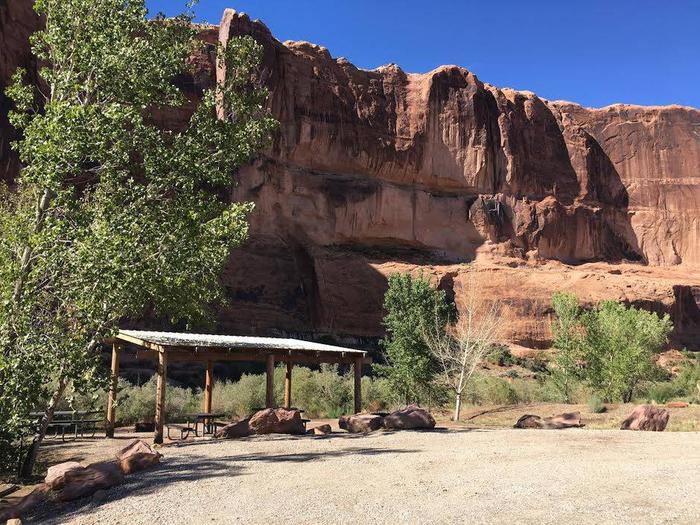
The group sites have fire grates, picnic tables, vault toilets and shade shelters. The group sites do not have water, dump stations or electric hook-ups. When you enter Goose Island the group sites are at the far end of the loop past the individual sites.

Natural Features

Goose Island is beside the Colorado River with cottonwood trees providing much sought after shade in the desert and striking canyon views. Across the river, the red cliffs of Arches National Park glow in the afternoon light.

Nearby Attractions

Goose Island is only 10 minutes from Arches National Park. Canyonlands National Park and Dead Horse Point State Park are within a half-hour drive. For people looking for guided tours or rentals, the town of Moab is only five minutes away.

Nearby Activities

  • Auto touring
  • Biking
  • Camping
  • Photography
  • Mountain biking
  • Scenic drive

Gallery

Directions

From Moab, drive north on Highway 191 to the junction of State Route 128. Drive two miles on SR 128 to the entrance to Goose Island campground. The group sites are at the far end of the campground.

GPS Coordinates

Latitude 38° 36′ 34.8098″ N

Longitude 109° 33′ 28.1498″ W

Categories
Uncategorized

Upper Onion Creek Group Site

Overview

Upper Onion Creek Group Sites are ideal for small family or group gatherings. Group Site A is designed for people with horses and has a horse corral and nearby equestrian trails. The campground offers striking views of the Colorado River canyon and the surrounding red rock cliffs, mesas and spires, with the La Sal Mountains as a dramatic back-drop. There is direct access to the Onion Creek four-wheel drive road (watch for seasonal rains and flash floods). The town of Moab is approximately 40 minutes away and has dining, shopping, sports rentals, tour companies and museums.

Recreation

Group Site A is designed for guests with horses and has a horse corral and nearby equestrian trails. Access to Onion Creek four-wheel drive road is adjacent to the campground and is popular for motorized and horse travel. The road has 27 wash crossings (be careful of seasonal rain and flooding hazards.) Within close proximity to national parks and open space, outdoor enthusiasts will enjoy hiking, mountain biking, whitewater rafting, and four-wheel drive tours in the surrounding area.

Facilities

Group sites have fire grates, picnic tables, vault toilets and shade shelters. Group Site A has a horse corral. The group sites do not have water, dump stations or electric hook-ups.

Natural Features

Upper Onion Creek Campground is located along scenic Highway 128. The views from the campground are spectacular and include Fisher Towers, Castle Valley and the Colorado River Canyon. The La Sal Mountains provide a stunning backdrop to the red rock cliffs, spires and mesas.

Nearby Attractions

There are many hiking trails and viewpoints along Highway 128. The Fisher Towers area offers hiking, rock climbing and scenic vistas. There are boat launches at nearby Lower Onion Creek and Hittle Bottom Campgrounds. Upper Onion Creek Campground is about 40 minutes from Arches National Park and 55 minutes from Canyonlands National Park.

Nearby Activities

  • Camping
  • Off highway vehicle
  • Horse camping
  • Mountain biking
  • Off road vehicle trails
  • Star gazing

Gallery

Directions

From Moab, drive north to Highway 128, turn right on 128. Between mile markers 21 and 22 you will see the sign marking the Onion Creek road. Turn right and go about a half a mile. The group areas are on the left side of the road.

GPS Coordinates

Latitude 38° 44′ 17.8400″ N

Longitude 109° 21′ 6.3698″ W

Categories
Uncategorized

Dewey Bridge Group Sites

Overview

The group sites at Dewey Bridge are located along the Colorado River and offer a wonderful retreat for adventurers looking to explore the area. Within close proximity to national parks and open space, outdoor enthusiasts will enjoy hiking, mountain biking, whitewater rafting, and four-wheel drive tours in the surrounding area. The town of Moab is approximately 45 minutes away and has dining, shopping, sports rentals, tour companies and museums.

Recreation

Dewey Bridge group sites are close to excellent four-wheel drive routes, mountain biking trails and river rafting. River trips often use these sites as a starting or ending point for river trips on the Colorado and Dolores Rivers.

Facilities

The Dewey Bridge group areas have fire rings, picnic tables, vault toilets and shade shelters. The group sites do not have water, dump stations or electric hook-ups. There is a boat ramp at the campground. Larger vehicles fit at this site, although trailer and RV parking is limited. (Multiple trailers and RVs can be accommodated at the Lone Mesa Group Sites along SR 313.)

Natural Features

Dewey Bridge is close to stunning vistas, scenic river ways, and impressive geology. With superb dark skies, visitors can enjoy a night of stargazing. The group sites are on the banks of the Colorado River with an adjacent boat ramp.

Nearby Attractions

The group sites are beside the Colorado River and scenic State Route 128 leads from Dewey to the town of Moab and nearby Arches and Canyonlands National Parks.

Nearby Activities

  • Auto touring
  • Boating
  • Camping
  • Hiking
  • Off highway vehicle
  • Recreational vehicles
  • Photography
  • Paddling
  • Mountain biking
  • Off road vehicle trails
  • Water activities
  • Canoeing
  • Star gazing
  • Non-motorized boating
  • Water access
  • Scenic drive
  • Rafting
  • River trips
  • Whitewater rafting

Gallery

Directions

From Moab, drive north to the junction with Highway 128. Turn right and travel 29 miles along the river road. The group sites are to your right as you enter the Dewey Bridge campground.

GPS Coordinates

Latitude 38° 48′ 37.6898″ N

Longitude 109° 18′ 27.3200″ W

Categories
Uncategorized

Homme Dam Recreation Area

This recreation area is part of Homme Lake

Directions

GPS Coordinates

Latitude 48° 24′ 11.5740″ N

Longitude 97° 47′ 34.2600″ W

Categories
Uncategorized

Desolation Gray Canyons of the Green River

Overview

The Green River enters Desolation Canyon just north of Sand Wash as it exits the Uinta Basin. Canyon walls are stream and lake deposits of the Eocene age then transition into the Cretaceous delta and sea deposits of Gray Canyon.

Along the river, the riparian zone holds willow, cottonwood, box elder and other woody riparian species and provides critical habitat to neo-tropical migrant birds, nesting waterfowl, and wintering deer and elk. Moving away from the cool shade of the riparian zone, one immediately enters a desert environment dominated by salt shrubs and bunch grasses. There is a small sagebrush zone that gives way to pinyon and juniper slopes. The view is always dominated by rock and cliff. Douglas fir finds a home in protected, well watered alcoves.

Over sixty riffles and rapids punctuate the trip. None are particularly difficult – a dozen or so can cause some trouble for the unprepared traveler. Camping tends to be idyllic on a clean sandy beach in front of a grove of cottonwood trees which offer shade and a windbreak. More than 60 side canyons descend from the plateau to meet the Green River. Every side canyon holds a surprise. In a few, a cold, clear stream pours into a warm silty river. Prehistoric rock art is prolific along with the ruins of dwellings, towers and granaries.

Between Sand Wash and Nefertiti Rapid, users set their own itinerary. There are a number of hiking trails in the canyon. Of the 84 mile long river segment, 66 miles are within the Desolation Canyon Wilderness Study Area – the largest in the lower 48 states.

The Desolation Canyon National Historic Landmark (NHL) extends one mile on either side of the river from Nine Mile Creek to Florence Creek. The NHL was designated by the Secretary of the Interior in 1969 as part of the centennial celebration of the 1869 exploration of the Green and Colorado Rivers by John Wesley Powell.

There is a primitive boat ramp at Sand Wash, a primitive eight-site campground, a contact/information station, staffed ranger station and toilets. Trash receptacles and water are not provided. With the remoteness of the area groups can camp the night before at Sand Wash. Due to frequent mosquito plagues, Sand Wash offers four campsites with screened cabins. Contact the Bureau of Land Managements (BLM) Price Field Office for cabin reservations at (435) 636-3600. This contrasts with the more developed Swaseys Boat Ramp where there is a large concrete boat ramp along with improved parking, toilets and trash removal services.

Directions

Shuttle Information: The one way drive time from Sand Wash to the take-out at Swasey’s Beach through Nine Mile Canyon is 4.5 to 5 hours, assuming there are good road and weather conditions. Three hours of the trip are on dirt roads with many twists and blind curves. Be safe, take your time.

Driving US Highway 40, going through Duchesne and Myton takes slightly longer, but with only an hour or so of dirt road. In wet conditions, this is the preferred route.

GPS Coordinates

Latitude 39° 50′ 21.9984″ N

Longitude 109° 54′ 51.0012″ W

Categories
Uncategorized

DESOLATION GRAY CANYONS SCREEN CABINS

Overview

The Green River splits the 10,000 foot high Tavaputs Plateau to form the rugged canyons of Desolation Gray Canyons. Access to the canyons is the Sand Wash Ranger Station, a remote primative boat ramp and campground. While the canyons and river can be remote, rugged and beautiful during the hot summer months, Sand Wash can be overrun by mosquitos. Weather can run the gamet from hot 100 degree days with no wind, to wind, rain, or snow. Screen cabins are provided to allow the boater an escape from the bugs and weather.

Recreation

Sand Wash is a destination for those that have a permit to float the Desolation and Gray Canyons of the Green River. Remote and primative, the area prepares the river runners for a relaxed river trip where solitude and nature abound. Historic and archaeogical sites are numerous on the river. River runners must be prepared to be self supported on the river.

Facilities

There is a primitive boat ramp at Sand Wash, a primitive eight-site campground, a contact/information station, staffed ranger station and vault toilets. This remote site does not provide trash receptacles or water. Due to the remoteness of the area, many groups camp the night here before their launch on the river. Due to frequent mosquito plagues, Sand Wash offers four campsites with screened cabins. Cabins are 12 feet by 16 feet, screen on all four sides with a door and roof. There is a small table and bench inside. Cabins are limited to two (2) per group launching. Please allow others the ability to escape the bugs. 

Natural Features

The Sand Wash boat ramp lies at the end of Sand Wash where a dirt road leads to a natural boat ramp for launching on the Green River. Cottonwood trees, cliffs, sage brush, and greasewood dot the area. Cottonwood trees do provide some shade.

Nearby Attractions

Launch point for the Green River through Desolation and Gray Canyons, 84 river miles before taking out at Swaseys Rapid. Nine Mile Canyon is within driving distance and is rich with rock art and historic sites.

Nearby Activities

  • Historic & cultural site
  • Camping

Gallery

Directions

From Vernal, Utah: Head some 40 miles southwest to the town of Myton. Just west of Myton, turn south off US 40 on the first paved road and follow the signs to Sand Wash Boat Ramp. Boaters must slow down and begin to enjoy the trip. Roads are graded gravel, good tires and spare tires are a must. Cell phone coverage is limited if help is needed.

From Duchesne, Utah: Head 17 miles east towards Myton. Turn south off US 40 onto Sand Wash road and follow the signs to Sand Wash Boat Ramp. Boaters must slow down and begin to enjoy the trip. Roads are graded gravel, good tires and spare tires are a must. Cell phone coverage is limited if help is needed.

GPS Coordinates

Latitude 39° 50′ 1.0000″ N

Longitude 109° 56′ 30.0001″ W

Categories
Uncategorized

Behind the Reef Trail

One of the BLM’s highlighted OHV/ATV trails within the San Rafael Swell this area provides a challenging off highway adventure and launching point for a variety of recreation activities. Jeepers, UTV’s, ATV’s, Mountain Bikes and hikers can all find their niche in this area. The main Behind the Reef trail turns into a 52” or less trail that exits around the Hidden Splendor Mine area while other routes provide recreational opportunities for all types of user groups. Please plan ahead this trail is difficult in rating and is located in a remote location with limited cell service available. Dispersed camping and hiking opportunities can be found throughout this area. The Behind the Reef trailhead is located on the west side of the San Rafael Reef. From Hwy 24, turn onto the Goblin Valley/Temple Mountain Road. Instead of turning down to Goblin Valley, continue west through the Reef. As you come out on the west side of the Reef you’ll see a well maintained road heading south marked as the Behind the Reef Road. Drive south on that road approximately 6 miles to the trailhead parking area, kiosk and registry box.

Directions

Please contact the Price Field Office for driving directions

GPS Coordinates

Latitude 38° 34′ 25.2800″ N

Longitude 110° 54′ 26.8301″ W

Categories
Uncategorized

Chute Canyon Trailhead

Chute Canyon trailhead is located along the Behind the Reef trail. This trail is popular by equestrian and hikers.

Directions

Please contact Price Field Office for driving diections

GPS Coordinates

Latitude 38° 37′ 30.2400″ N

Longitude 110° 45′ 59.5102″ W

Categories
Uncategorized

Crack Canyon Trailhead

Crack Canyon is one of the many slot canyons in the Crack Canyon WSA. This hike can be accessed by the Behind the Reef Trail. The canyon has three sections on narrows that can be completed by experiences hikers. Spring and Fall are ideal times to hike these canyons. Always be aware if the extreme flash flood potential.

Directions

Please contact Price Field Office for driving diections

GPS Coordinates

Latitude 38° 38′ 34.5000″ N

Longitude 110° 44′ 42.7700″ W

Categories
Uncategorized

Little Wild Horse Trailhead

Little Wild Horse and Bell Canyons is the most popular of the slot canyons in the Crack Canyon WSA. This hike is a 8 mile loop and will take close to 4 hours to complete. The canyons have extreme potential for flash floods Please use extreme caution and pay attention to the weather.

Directions

From highway 24 turn west on to Temple Mountain Road. Travel 5 miles along Temple Mountain Road and turn south on Goblin Valley Road. Continue south on Goblin Valley Road for 6 miles. Turn west on Wild Horse Road and continue 5 miles to Little Wild Horse Trailhead.

GPS Coordinates

Latitude 38° 34′ 58.7800″ N

Longitude 110° 48′ 10.4400″ W