Categories
Uncategorized

South Fork of the Snake River: Conant Boat Access

This BLM site features a concrete boat ramp and separate raft launch facilities. There is a large pool to launch boats and a back channel for rafts. The river has roller coaster waves and turbulent water upstream. Motorized boats beware of the gravel bar in front of the boat ramp.

There is a small visitor information station with displays which is staffed part-time during the summer season.


Users of this BLM site are required to fill out a self-issue permit and pay a parking fee ($3.00). This site is equipped with flush and pit toilets, some shade, water, picnic tables, trash cans, and seasonal hosts.


Day use only, no overnight camping.


There are several camping sites along the river corridor (see attached map below) and there is an overnight self-issue permit station at this facility–users can view and print permit before going as well (see attached permit below).

Directions

This boat ramp is located off of Conant Valley Loop in Swan Valley, just off of the Swan Valley Highway.

GPS Coordinates

Latitude 43° 26′ 59.0000″ N

Longitude 111° 23′ 55.0000″ W

Categories
Uncategorized

South Fork of the Snake River: Byington Boat Access

This BLM site features a concrete boat ramp and separate raft launch/takeout facilities.


Users of this BLM site are required to fill out a self-issue permit and pay a parking fee ($3.00). This site is equipped with toilets, some shade, water, picnic tables, trash cans, and seasonal hosts.


Day use only, no overnight camping. If the visitor is looking for camping areas, there is a BLM site across the river from Byington Boat Access called Kelly Island Campground.

Directions

Take the Swan Valley Highway out of Idaho Falls. Turn north onto 175 E and then turn east on 143 N.

GPS Coordinates

Latitude 43° 37′ 23.0000″ N

Longitude 111° 39′ 56.0002″ W

Categories
Uncategorized

Roadrunner Campground

Roadrunner Campground is the second largest campground offering a large loop of paved roads. Two vaulted toilets are available.

Nearby Activities

  • Auto touring
  • Camping
  • Off highway vehicle
  • Recreational vehicles
  • Wildlife viewing
  • Photography

Directions

Access to the Imperial Sand Dunes Recreation Area is best made along Highway 78 located East of Brawley, California. Turn onto Gecko Road and the campground is located at the end of the road.

GPS Coordinates

Latitude 32° 54′ 42.0000″ N

Longitude 115° 7′ 4.0001″ W

Categories
Uncategorized

Midway Campground

Midway Campground is located off of Grey’s Well Road and offers visitors areas to camp. Vaulted toilets and dumpsters are available on site.

Nearby Activities

  • Auto touring
  • Camping
  • Wildlife viewing
  • Photography

Directions

Access to Midway Campground is best made by taking Gray’s Well Road Exit off of Interstate 8. Follow Gray’s Well Road past the Buttercup Ranger Station and continue west.

GPS Coordinates

Latitude 32° 42′ 57.0000″ N

Longitude 114° 54′ 52.9999″ W

Categories
Uncategorized

Keyhole Campground

Keyhole Campground is the smallest campground located within the Imperial Sand Dunes Recreation Area. It is a small paved “keyhole” offering a large group or few small groups an area to camp.

Nearby Activities

  • Auto touring
  • Camping
  • Off highway vehicle
  • Recreational vehicles
  • Wildlife viewing
  • Photography

Directions

Access to the Imperial Sand Dunes Recreation Area is best made along Highway 78 located East of Brawley, California. Turn onto Gecko Road and the campground is located on the left hand side of the road.

GPS Coordinates

Latitude 32° 54′ 54.0000″ N

Longitude 115° 7′ 4.0001″ W

Categories
Uncategorized

Buttercup Ranger Station

Buttercup Ranger Station is located off of Grey’s Well Road near Interstate 8. This station offers visitors a location to purchase their dunes permit, gather information and seek medical aid. This station is open Friday through Sunday from mid-October to mid-April during the high visitation period.

Directions

Access the Buttercup Ranger Station by traveling on Interstate 8. Exit onto Gray’s Well Road exit and continue west.

GPS Coordinates

Latitude 32° 44′ 19.6300″ N

Longitude 114° 53′ 8.1398″ W

Categories
Uncategorized

North Algodones Dunes Wilderness

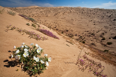
The North Algodones Dunes Wilderness encompasses more than 26,000 acres. Other specially designated areas found within this wilderness include the Imperial Sand Hills National Natural Landmark and the Algodones Outstanding Natural Area.

The Wilderness is divided into two distinct zones. On the west side are the primary dunes, the largest and tallest dunes composed of relatively coarse sand. On the east are the secondary dunes, smaller and composed of generally finer sands carried further east by prevailing winds.

A parking area with access to the wilderness site is a perfect place to discover a variety of plant and animal species.

Visitors are welcome to walk or ride horses in this remote area. The wilderness is closed to all vehicles and mechanized use.

Gallery

Directions

Located north of State Highway 78, the wilderness extends from the east side of the Coachella Canal to the town of Glamis. Access the east side of the Dunes from Glamis on the Niland/Glamis County Road, which continues for approximately 10 miles and forms the eastern boundary of the wilderness.

GPS Coordinates

Latitude 33° 1′ 53.3856″ N

Longitude 115° 10′ 56.6760″ W

Categories
Uncategorized

Gecko Campground

Gecko Campground is the largest campground in the Imperial Sand Dunes Recreation Area. It consists of a north loop and a south loop. These loops are paved roads and offer numerous vault toilets.

Nearby Activities

  • Auto touring
  • Camping
  • Off highway vehicle
  • Recreational vehicles
  • Wildlife viewing
  • Photography

Directions

Access to the Imperial Sand Dunes Recreation Area is best made along Highway 78 located East of Brawley, California. Turn onto Gecko Road and the campground is located on the left hand side of the road.

GPS Coordinates

Latitude 32° 56′ 23.0000″ N

Longitude 115° 8′ 34.0001″ W

Categories
Uncategorized

Cahuilla Ranger Station

Cahuilla Ranger Station is located off of Gecko Road. This station offers visitors a location to purchase their dunes permit, gather information and seek medical aid. This station is open Friday through Sunday from mid-October to mid-April during the high visitation period.

Directions

Access the Cahuilla Ranger Station by traveling on Highway 78 to Gecko Road. Turn onto Gecko Road and the ranger station is located on the right hand side of the road.

GPS Coordinates

Latitude 32° 58′ 23.4600″ N

Longitude 115° 10′ 21.6300″ W

Categories
Uncategorized

Bayshore Resort

This recreation area is part of Ashtabula Lake

Directions

GPS Coordinates

Latitude 47° 5′ 45.5572″ N

Longitude 98° 0′ 26.4312″ W