Categories
Uncategorized

Wolford Red Desert Overlook

The Wolford Mountain area provides unrestricted use for the foot traffic throughout the area. The 0.2 – mile Wolford Reservoir trail is designated for foot and horse traffic. The trail descends through the sagebrush habitat, providing access to the shore of Wolford Mountain Reservoir. The area is intermixed with Private property.

Directions

It is located approximately eight miles north of Kremmling on Highway 40. Turn East into the Red Desert Overlook day use area.

GPS Coordinates

Latitude 40° 10′ 3.1080″ N

Longitude 106° 25′ 0.9120″ W

Categories
Uncategorized

Muddy Creek Fishing Access and Kremmling Cliffs

Muddy Creek is a tributary of the Colorado River and provides anglers another great option to pursue both Rainbow and Brown trout in the Colorado River Basin. The creek is split in half by Wolford Reservoir and the most popular section to fish is the tailwater section below the dam. The majority of the river above the reservoir is privately owned. Below the dam, anglers have approximately 5 miles of river to explore. The river sits in a fairly wide open meadow and doesn’t provide much protection from the elements. The trout in Muddy Creek grow to respectable sizes and 14″-16″ fish are not uncommon. Reports of fish much larger than that below the dam are somewhat frequent as well. Trails offer access upstream and downstream for access to approximately 1.5 miles of Muddy Creek. There is a vault restroom at the parking area. For more Information, please contact the Kremmling Field Office.

Directions

Muddy Creek Fishing Access is located three miles north of Kremmling and east of U.S. Highway 40. From the town of Kremmling, take Hwy 40 west for approximately three miles. Turn east following County Road 227 for 0.6 mile. At the top of the ridge, turn left on BLM Road 491, ending at the Muddy Creek Fishing Access parking area.

GPS Coordinates

Latitude 40° 5′ 14.2800″ N

Longitude 106° 24′ 27.4320″ W

Categories
Uncategorized

Sidewinder Trail

Recommended Users: Mountain Bikers, Hikers. Singletrack trail. 1.7 miles in length. Difficulty: Moderate/More Difficult (IMBA Trail Difficulty Rating System). Sidewinder can be reached from two trails: Barrel Roll and Precipice. As its name implies it gently winds up a narrow little mesa through a series of switchbacks. At the top of the mesa the trail forms a small loop to take advantage of the terrain and spectacular views. Although the plant community is a typical black brush desert, there are some interesting eroded rock features and views of Santa Clara River and surrounding mesas that are hard to beat.While it may be tempting to ride or hike off trail, particularly straight up or straight down, don’t. This mesa, like the other mesas nearby, has substantial areas of cryptobiotic soils. Many of the desert’s smallest wildflowers also find a home on the mesa’s slopes, but can’t be seen until bloom time in Spring.

Directions

Cove Wash Trailhead – From I-15 Exit 6 turn north on Bluff Street. Turn left on Sunset Blvd. Continue on Sunset Blvd as it turns into Santa Clara Drive. Turn left on Gates Lane (just before reaching the Jacob Hamblin Home on the right). Cross the river and at 0.4 miles turn left (leaving the pavement). Note that the road from this point is steep and rocky, and can be eroded. At 0.7 miles turn right (at sign for Reserve). At 0.7 miles turn right (at sign for Reserve). Pass the water tank, and at 1.3 miles turn right (at sign for reserve). Follow the road around to the left and park in the trailhead at 1.5 miles.

GPS Coordinates

Latitude 37° 7′ 20.1176″ N

Longitude 113° 41′ 47.3305″ W

Categories
Uncategorized

Animas/Grandview/Skyline RMZ

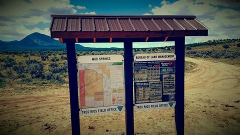
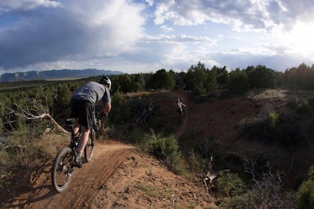
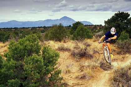
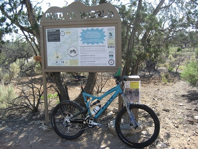
Within this Recreation Management Zone are three isolated parcels of BLM managed lands which are popular for non-motorized trail activities. The Grandview and Skyline parcels are connected to each other via the Horse Gulch trail system (managed by the city of Durango). The trail system spans a large spectrum of difficulty levels and are heavily used by bikers and hikers/walkers/runners alike. The Animas City Mountain unit contains about 5 miles of trail beginning at 6700′ and climbing up to 8,200 ‘, presenting stunning views of the Durango area and Animas River Valley. This trail system is primarily used by hikers and trail runners, but receives mountain bike use as well. The lower portion of the trail system, in and adjacent to Dalla Mountain Park (managed by the city of Durango), is popular for bouldering. For more information, please contact the Tres Rios Field Office.

Directions

The Grandview Ridge and the Skyline area are located on the eastern edge of Durango. The trailheads are all located on city or private property. The Skyline trail is accessed off of the north end of Jenkins Ranch Road, and the Grandview Ridge trails are accessed at three trailheads (Carbon Junction, Big Canyon, and Sale Barn) off of Highway 160, south of Durango. Carbon Junction is technically accessed off of old Highway 3. Animas City Mountain is located at the northern end of Durango. From Main Street, turn west on 32nd street and right on West 3rd Ave. Or, from Main Street, turn west on 25th Street (Junction Creek Road) and access the trails via Dalla Mountain Park.

GPS Coordinates

Latitude 37° 13′ 25.8240″ N

Longitude 107° 51′ 22.7160″ W

Categories
Uncategorized

Mud Springs RMZ

The main recreational planning emphasis for the Mud Springs area is for motorized trails and rock crawling opportunities, though there are also about 4 miles of non-motorized trails as well. The motorized trails are converted full sized vehicle routes which access three ‘Open’ OHV play areas. Two of these open areas are for rock crawlers (super modified 4-wheel drive vehicles), and one is for ATV/UTVs. For more inrfomation, please contact the Tres Rios Field Office.

Gallery

Directions

Mud Springs is located about 6 miles SW of Cortez. To get there from Cortez, travel south on Highway 491 about 2 miles to McElmo Canyon/County Road G. Turn east at the light and drive 2.75 miles to County Road 21. Turn south. The Mud Springs parking lot/Trailhead will be on the west side of the road after approximately .75 miles.

GPS Coordinates

Latitude 37° 18′ 8.2512″ N

Longitude 108° 39′ 49.9392″ W

Categories
Uncategorized

Phil’s World

The Phil’s World Trail system is part of the Cortez Special Recreation Management Area (SRMA) with an emphasis on non-motorized trail opportunities. There are 15 miles of designated non-motorized trails on BLM (27 miles including adjacent State Lands under lease by Southwest Colorado Cycling Assn) and 13 miles of designated OHV trails on BLM. The Phil’s World area is relatively flat, comprised of rolling mesa tops bisected by small but scenic canyons. The non-motorized trails are best described as ‘flow trails’ with low to moderate technicality. The trails are used intensively by mountain bikers, but open to other non-motorized users as well. Mountain bike use is limited to clockwise travel to reduce social congestion. The motorized trails are relatively flat and easy to navigate as well. For more information, please contact the Tres Rios Field Office.

Gallery

Directions

The trailhead for Phil’s World is located 3 miles East of Cortez, on the north side of Highway 160. It is located on State Land and accessed by Road 30.1 across from the Montezuma County Fairgrounds. Motorized trail users can start here, though they more commonly access the trails by continuing past the main trailhead, turning north on the first side road and either parking there, or continuing ѕ of a mile to an OHV open play area.

GPS Coordinates

Latitude 37° 21′ 36.2880″ N

Longitude 108° 29′ 45.0240″ W

Categories
Uncategorized

North Fork Trail Shelter

North Fork Shelter Cabin is located approximately 18 trail miles (6.2 km) from Eagle Summit Wayside on the Pinnell Mountain National Recreation Trail on the back side of a hill. Conversely, it is 9 miles from the Twelvemile Summit Wayside. This small cabin is available on a first-come, first-served basis and is primarily intended as an emergency shelter. The cabin includes a water catchment system for collecting rain and melting snow; water should be treated before cooking or drinking.

Directions

From the Twelvemile Summit Wayside, milepost 85.5 on Steese HIghway, go 9 miles northest on the Pinnell Mountain National Recreation Trail.

GPS Coordinates

Latitude 65° 28′ 43.7000″ N

Longitude 145° 49′ 2.7998″ W

Categories
Uncategorized

Ptarmigan Cr Tr Shelter

This small cabin is available on a first-come, first-served basis and is primarily intended as an emergency shelter. The cabin includes a water catchment system for collecting rain and melting snow; water should be treated before cooking or drinking. There is no stove in this shelter cabin, as it is intended only as a shield to the weather. Expect to camp at least one night along this 27mile trail.

Directions

Ptarmigan Creek Shelter Cabin is located approximately 10 trail miles (6.2 km) from Eagle Summit Wayside on the Pinnell Mountain National Recreation Trail in a saddle just below Pinnell Mountain.

GPS Coordinates

Latitude 65° 30′ 10.5000″ N

Longitude 145° 37′ 45.7000″ W

Categories
Uncategorized

South Fork of the Snake River: Menan Boat Access

This BLM site features a narrow concrete boat ramp. The current is a little swift by the boat ramp. Watch for underwater hazards near the access.


Users of this BLM site are required to fill out a self-issue permit and pay a parking fee ($3.00). This site is equipped with toilets, some shade, trash cans, and no water.


Day use only, no overnight camping.

Directions

Off of the Menan Lorenzo highway, turn north onto 3600 E. Menan Boat Access is the dirt road to the east just before the bridge.

GPS Coordinates

Latitude 43° 45′ 5.0000″ N

Longitude 111° 58′ 45.9998″ W

Categories
Uncategorized

South Fork of the Snake River: Lorenzo Boat Access

This BLM site features a concrete boat ramp and the boat launch is located off of the Menan exit on highway 20.


Users of this BLM site are required to fill out a self-issue permit and pay a parking fee ($3.00). This site is equipped with toilets, some shade, trash cans, and no water.


Day use only, no overnight camping.

Directions

Take exit 325 to Menan off Highway 20. Head west approximately .2 miles and turn onto the dead-end road heading back towards Highway 20. The first road on the left is the Lorenzo access road, a long gravel road headed north, located adjacent to a stone wall sound barrier.

GPS Coordinates

Latitude 43° 44′ 12.0000″ N

Longitude 111° 52′ 53.0000″ W