Overview
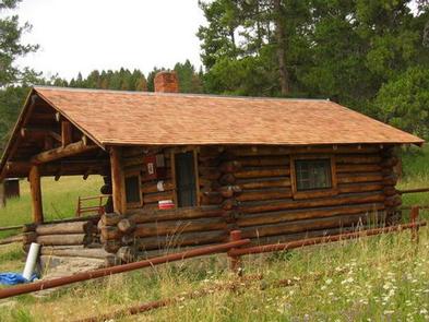
Ibex Cabin was constructed in 1939 as a shelter for Forest Service rangers working within the Shields Ranger District of the Gallatin National Forest of south-central Montana. It is available for summer and winter recreational use, and provides a peaceful, remote mountain retreat.
Guests can drive to the cabin from June until the snow flies. The cabin is closed April and May due to road and wildlife protection. High clearance, four-wheel drive vehicles are strongly recommended. The access road to the cabin may get muddy in the rain, so guests may want to call ahead for road conditions. In the winter, the cabin is only accessible by a 5.5-mile ski, snowshoe or snowmobile trip. Guests are responsible for their own travel arrangements and safety.
This cabin offers very rustic accommodations with limited amenities, so guests should be
prepared to bring most of their own supplies and gear to make their stay an enjoyable experience.
Recreation
There are a number of trails in the area for hikers, equestrians and snowmobilers. Tresspass Trail and Cottonwood Lake Trail are good trails in the area to explore. Trails in the area may cross private property,so guests MUST stay on the trail.
Winter recreation includes snowshoeing and cross-country skiing. Big game hunting is also a popular activity in this area.
Facilities
The cabin has bunk beds with mattresses to accommodate up to four people. Other amenities include a wood stove for heat, a propane lantern ( bring propane cannisters), table, chairs, axe, splitting maul, bucket, broom, mop and shovel.
An outhouse with vault toilet is located outside.
FIREWOOD IS NOT AVAILABLE FROM JUNE 1ST THROUGH SEPTEMBER 30TH. PLEASE BRING FIREWOOD OR GATHER FROM FOREST DURING SUMMER.
DO NOT BURN PROVIDED FIREWOOD FOR OUTDOOR FIRES, EVER, AS IT IS EXTREMELY DIFFICULT TO REPLACE. Firewood is available during winter months as long as supplies last. A campfire ring is located outside, (collect wood in forest nearby or bring firewood for outside fires).
Electricity and water are not available. Guests must bring their own water supply, as well as cooking gear, propane canisters for the lantern, bedding, matches, newspaper, first aid kit, dishes and utensils, toilet paper and other necessities. The cabin will need to be cleaned and all trash carried out, prior to leaving.
Natural Features
The rustic cabin is nestled at the edge of a meadow in the foothills of the Crazy Mountains, at an elevation of 6,600 feet. A forest of Lodgepole pine grows behind the cabin, and views from the front reveal the 7,354-foot peak of Ibex Mountain.
The surrounding meadow bursts with color from wildflowers in the summer. Mule deer, porcupine and elk may be spotted around the cabin. Several bird species that inhabit this area include bald eagles, owls, jays, western meadowlarks and mountain bluebirds.
Nearby Activities
- Camping
- Hiking
- Hunting
- Winter sports
- Wildlife viewing
Gallery
Directions
From Livingston, travel north on U.S. Highway 89 just past Clyde Park. Turn right onto Cottonwood Bench Road and continue 3 miles. Turn right onto Cottonwood Road and proceed for about 7 miles, to the intersection of Upper Cottonwood Creek Road and Lower Cottonwood Road. Turn left on Upper Cottonwood Creek Road. Take the next right,
continuing on Upper Cottonwood Creek Road. Continue approximately 4.5 miles to an intersection and bear left onto Ibex Road, following the signs for the next 2.5 miles to the cabin. (High clearance four-wheel drive vehicles are recommended due to the rough road conditions).
In the winter, park at the winter parking area at the intersection of Briggs Lane and Upper Cottonwood Creek Road, which is approximately 9 miles from U.S. Highway 89. Ski, snowshoe or snowmobile the remaining 5.5 miles to the cabin.
The Cottonwood area can be extremely windblown during the winter months. Roads drift in with snow quickly during high winds and may not be plowed for 24 to 48
hours. It is recommended that winter guests carry topographic maps and compasses for navigation since the route may be windblown and difficult to find. The signs might be down due to weather conditions or vandalism.
GPS Coordinates
Latitude 46° 0′ 11.0002″ N
Longitude 110° 26′ 29.0000″ W

