Categories
Uncategorized

Oak Creek Canyon

View of Oak Creek Canyon

View of Oak Creek Canyon from Oak Creek Vista


Oak Creek Canyon is a gorge carved into the edge of the Mogollon Rim of the Colorado Plateau along the Oak Creek Fault. Tectonic forces shifting the land to either side of the fault and subsequent erosion by Oak Creek have created a spectacular canyon where the geologic history of this area is an open book.

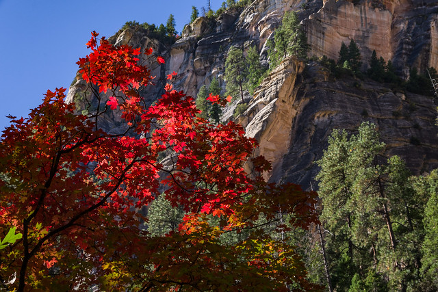
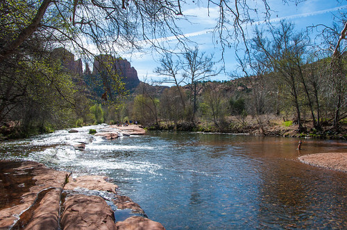
The Canyon is approximately 12 miles long. Oak Creek flows year-round along the bottom of the Canyon, providing water for plants and wildlife, as well as fishing and swimming opportunities. Oak Creek continues on through Sedona, Arizona, meeting up with the Verde River southeast of Cottonwood, Arizona.

The depth of the Canyon ranges from 800 to 2000 feet, with trails providing access from the Canyon’s bottom up to the 6500-foot eastern rim and 7200-foot western rim. Some of these trails follow historic routes early Oak Creek Canyon settlers used to access the top of the plateau in the days before the road was built. Trails on the west side of the Canyon head into Red Rock-Secret Mountain Wilderness.


The Creation of Oak Creek Canyon

Approximately 65 million years ago, during a period of great mountain building, movement along Oak Creek Fault caused the east side of what is now Oak Creek Canyon to shift upwards approximately 600 feet. The exposed top rock layers eroded away until the eastern and western sides of the fault were level once again.

A few more millions of years passed, and a canyon had formed. Streams carrying gravel, then lava, flowed into the canyon from the north. In the past six million years, the fault became active again and the modern Oak Creek Canyon was carved along it. This time, the fault caused the eastern rim of the Canyon to drop around 700 feet lower than the western rim.

One of the best places to get the big picture view of the Canyon’s fascinating geologic history is Oak Creek Vista. The Vista provides a view from the top of the Canyon, where the eastern drop is easily seen.

Learn more about the geology of Oak Creek Canyon (U.S. Forest Service).


Enjoying the Canyon

Oak Creek Canyon offers hiking, picnicking, camping, fishing, swimming, and endless vistas of colorful, soaring cliffs. The following resources will help you get the most from your visit:

Directions

Visiting Oak Creek Canyon: Oak Creek Canyon is accessed by Arizona State Route 89A, which runs through the Canyon from Flagstaff, Arizona, to Sedona, Arizona. The drive from Flagstaff to Sedona takes approximately 45 minutes.

Just past Oak Creek Canyon Vista, 12 miles south of Flagstaff, SR 89A drops steeply into the Canyon, making several hairpin turns. At the bottom, the highway winds through the Canyon for 13 miles on its way to Sedona, following Oak Creek.

Trailheads, day use areas, and pull-offs along the road provide ample opportunities to stop and enjoy the scenery.

GPS – approximate center of Oak Creek Canyon (Map): 34°57’11.8″N 111°45’15.8″W

Maps

GPS Coordinates

Latitude 34° 57′ 11.7936″ N

Longitude 111° 45′ 15.8292″ W

Categories
Uncategorized

White Bridge Picnic Site

White Bridge Picnic Site is a developed picnic area with toilets and picnic tables. Access to the Verde River and non-motorized boating, fishing and nature viewing are just some of the activities you will enjoy here. Overnight camping is not permitted at this site.

Facilities include:

  • 4 picnic tables with pedestal grills
  • 1 large ramada
  • No drinking water
  • Vault toilet
  • No garbage service: Pack it out!


Directions

Location: In Camp Verde, Arizona, on the corner of Arizona State Route 260 and Quarterhorse Lane, diagonally across SR 260 from from the Verde Ranger Station.

Directions: From I-17, go east on SR 260. Take the first right after the bridge crossing the Verde River.

GPS (Map): 34°32’58.3″N 111°51’02.2″W

GPS Coordinates

Latitude 34° 32′ 58.3404″ N

Longitude 111° 51′ 2.1672″ W

Categories
Uncategorized

West Fork of Oak Creek No. 108

There are a number of reasons why West Fork is one of the most popular trails on the Coconino National Forest. Once you’ve strolled beside the pleasant little stream that ripples along the canyon floor and looked up, way up, at the dizzying cliffs that tower above it, you will fall in love with it, too. West Fork is fantastic throughout the year. In springtime, migrating songbirds decorate the trees with flashes of brilliance. In autumn, the canyon is ablaze with color, with red and gold leaves floating in clear reflecting pools under a canopy of solid color. In wintertime, icicles decorate from red rock overhangs, and snatches of snow persist in cool shadows. As a matter of fact, you’ll probably find a new reason to be here every time you visit.

As for the trail itself, it’s an easy stroll, but you do have to cross the stream in a number of places. Usually, that involves negotiating a few strategically placed stepping stones or taking a couple of steps in shallow water. The trail is marked and maintained for the first three miles.

Many hikers explore beyond the end of the maintained trail. Eventually the pathway ends, the route becomes more strenuous, and you will be forced to hike in the stream bed as you continue into the Red Rock-Secret Mountain Wilderness. If you choose to travel the entire 14 mile stretch from one end of the canyon to the other, plan to do a lot of wading and boulder hopping, and even some swimming. Please read this notice describing the strenuous 14 mile long full canyon route between SR 89A to FR 231 (Woody Mountain Road) before attempting this rugged wilderness route. 

No matter how long a hike you take here, you’ll enjoy it best if you come at a time when the trail is least crowded. Mornings and weekdays are best, better yet if they’re in the off-season.

When you do come, remember to take special care and leave this beautiful place better than you found it. Of course you know not to litter, but picking flowers and autumn leaves can cause just as unsightly a scar. So can short-cutting or rock throwing. Treat this natural treasure with the care it deserves and you’ll have plenty of reason to come back and see it again and again.


Hover mouse over photo to display slideshow controls. View album on Flicker

Trails: West Fork of Oak Creek Canyon No. 108


Directions

Location: 17.5 miles south of Flagstaff (9.5 miles north of Sedona) on paved roads in scenic Oak Creek Canyon.

Access: Drive south 17.5 miles south from Flagstaff or north 9.5 miles from Sedona to about halfway between milepost 385 and 384. The trailhead is on the west side of the highway down a paved lane that leads behind a few creekside houses. Park at the Call O’ The Canyon day-use area.

GPS (Map): 34°59’26.5″N 111°44’34.6″W

Maps


Click map thumbnail for larger view.

Map showing the West Fork Trail


GPS Coordinates

Latitude 34° 59′ 26.0160″ N

Longitude 111° 44′ 35.5020″ W

Categories
Uncategorized

Stoneman Lake

There is still some debate over whether Stoneman Lake is the remains of a volcanic crater or whether it fills a deep, collapsed sinkhole. The location of this naturally occurring body of water at the bottom of a large bowl-shaped valley and its nearly circular shape actually support both conclusions. The fact that faults in underlying rock layers provide the only way for water to leave the lake, adds weight to the sinkhole conclusion.

The lake’s recreational value, on the other hand, is something that is easily agreed upon. This medium-sized body of water, surrounded by Gambel oak and ponderosa pine covered basalt slopes is an excellent place to bird watch during the yearly waterfowl migrations, or all summer long for songbirds.

There is a gravel parking lot and boat ramp at a day use area on the lake’s northern shore. Picnic tables at shaded sites nearby provide a good place to spend an afternoon.

Campground Season: There are no campgrounds at Stoneman Lake. Camping is available to the north at Mormon Lake and to the south at Beaver Creek. Please view “Dispersed Camping Guidlines” for camping in the area.

Attractions: Boating (single electric motors only), Picnicking, Wildlife viewing, Photography

Facilities: Gravel boat ramp and parking area, Picnic tables, Vault toilets

Notes:

  • No camping is permitted at the day-use area. Boats may be powered with no more than a single electric motor.
  • The last 4 miles of road into the lake are not suitable for passenger cars in wet weather.
  • There are a number of private cottages near the lake. Please respect their privacy.

Directions

Location: 46 miles south of Flagstaff on paved and graveled roads. Elevation is 6900 feet.

GPS (Map): 34°46’59.4″N 111°31’19.5″W

Access: Drive 36 miles south of Flagstaff on I-17, and take the Stoneman Lake Exit (Exit 306). Turn east under the highway and follow Forest Road 213 about 6.3 miles. Turn north (left) at the T to stay on FR 213. Follow FR 213 for about 2 miles and then turn left on FR 665 then right immediately on FR 213A and drive 0.5 miles to the day-use area.

GPS Coordinates

Latitude 34° 46′ 59.5236″ N

Longitude 111° 31′ 19.3800″ W

Categories
Uncategorized

Stage Stop Day Use Area

The stage stop site is just south of the Red Rock Ranger District office, at the south end of the Village of Oak Creek. It is not really a “trailhead”, rather a parking area from which people can explore along Dry Beaver Creek.

Notes:

  • No overnight camping
  • No campfires

Directions

GPS (Map): 34°42’54.2″N 111°46’43.1″W

GPS Coordinates

Latitude 34° 42′ 54.1660″ N

Longitude 111° 46′ 43.0649″ W

Categories
Uncategorized

Halfway Picnic Site

Red Rock Pass Sold Here!

Few places offer a more scenic setting for a picnic than Oak Creek Canyon. Home of a bubbling brook that flows through a lush green oasis framed by towering red rock cliffs and buttes, this canyonscape is known around the world for its unmatched beauty.

This is one of four easily accessible picnic areas along Oak Creek Canyon that enable you to enjoy a snack or a banquet surrounded by this magnificent scenery. Each of these areas has its own unique character. Each has hiking trails and the shimmering clear water pools of Oak Creek nearby. If you’ve an appetite for beauty, here’s a place to indulge it.

Attractions: Picnicking, waterplay, hiking, fishing, wildlife watching, photography

Directions

Location: 20 miles south of Flagstaff, 5 miles north of Sedona on a paved road in scenic oak Creek Canyon. Elevation is 4,500 feet.

GPS (Map): 34°57’22.8″N 111°45’18.1″W

Access: Drive south from Flagstaff about 20 miles or north from Sedona for about 5 miles on US 89A. The picnic area is marked with a roadside sign.

GPS Coordinates

Latitude 34° 57′ 22.9680″ N

Longitude 111° 45′ 22.2120″ W

Categories
Uncategorized

Crescent Moon Picnic Site

One of the most photographed scenes in the southwest is towering Cathedral Rock reflected in the waters of Oak Creek at Red Rock Crossing. It should come as no surprise, then, that the picnic area located at that same site is as popular as it is beautiful. People come here to fish, swim, and wade in the creek, as well as to picnic and photograph the scenery. At times it can become quite crowded. But if you come early in the morning or on a weekday, it’s possible to have the world class beauty of Red Rock Crossing all to yourself, or nearly so.


Crescent Moon Ranch


Fourth graders! The Every Kid in a Park 4th Grade Pass will be honored through 2018!

Attractions: Picnicking, waterplay, wildlife watching, photography, and fishing.

Directions

Location: 37 miles south of Flagstaff, 7 miles southwest of Sedona. Elevation is 4,000 feet.

GPS (Map): 34°49’35.7″N 111°48’25.5″W

Access: Drive west from Sedona on US 89A. Just outside town, turn south on FR 216 (Upper Red Rock Loop Road). Drive about 1.5 miles and follow the signs to Red Rock Crossing. All roads except the short segment leading from Red Rock Crossing Road to the picnic area are paved.


Maps

  • Red Rock Country Maps: Download Red Rock Country trail maps and find other Sedona recreation resources. See the Sedona Southwest map for this trail.
  • The Digital Travel Map: Whether you’re driving, hiking, riding, or exploring, you will find this full-color, GPS-enabled map a handy reference to have on your mobile device. The map show trails, recreation sites, major landmarks, and forest roads.
  • Printed Maps: A variety of printed recreation maps for Sedona and Oak Creek Canyon can be purchased in our local offices and visitor centers, or ordered by phone.


Click map thumbnail for a larger view.

Map to Crescent Moon Picnic Area


GPS Coordinates

Latitude 34° 49′ 35.7312″ N

Longitude 111° 48′ 25.5204″ W

Categories
Uncategorized

Clear Creek Day Use Picnic Site

This is a day use site with a toilet. No overnight camping.

Directions

GPS Coordinates

Latitude 34° 30′ 54.5004″ N

Longitude 111° 45′ 54.5328″ W

Categories
Uncategorized

Call of the Canyon Picnic Site

Fourth Graders! The Every Kid Outdoors 4th Grade Pass will be honored through 2018!

This picturesque day use site in Oak Creek Canyon is at the trailhead of the West Fork of Oak Creek Trail. The trail follows the West Fork stream into a side canyon of Oak Creek Canyon, rich with maples and breathtaking beauty. Bring a picnic, your camera, and go for a hike!

For more information, see West Fork of Oak Creek Trail #108.

Photos & Multimedia

Directions

Location: 17.5 miles south of Flagstaff (9.5 miles north of Sedona) on paved roads in scenic Oak Creek Canyon.

GPS (Map): 34°59’26.4″N 111°44’32.7″W

Access: Drive south 17.5 miles south from Flagstaff or north 9.5 miles from Sedona to about halfway between milepost 385 and 384. The West Fork of Oak Creek trailhead is on the west side of the highway down a paved lane that leads behind a few creekside houses.


Maps

  • Red Rock Country Maps: Download Red Rock Country trail maps and find other Sedona recreation resources. See the Oak Creek Canyon North map for this site.
  • The Digital Travel Map: Whether you’re driving, hiking, riding, or exploring, you will find this full-color, GPS-enabled map a handy reference to have on your mobile device. The map show trails, recreation sites, major landmarks, and forest roads.
  • Printed Maps: A variety of printed recreation maps for Sedona and Oak Creek Canyon can be purchased in our local offices and visitor centers, or ordered by phone.


Click map thumbnail for larger view.

Map showing the West Fork Trail

GPS Coordinates

Latitude 34° 59′ 26.4516″ N

Longitude 111° 44′ 32.7120″ W

Categories
Uncategorized

Bootlegger Picnic Area

Red Rock Pass Sold Here!

At this creekside picnic area you’ll have a fishing hole and that’s not all. Add spectacular scenery, clear water swimming holes, picturesque hiking trails and excellent wildlife watching (in other words, the standard amenities of Oak Creek Canyon) and it should come as no surprise that these pieces of recreational real estate are in high demand.

The decor at this day-use site is Arizona ash and box elders, gravel beaches and stream-bed boulders. The creek is regularly stocked with trout. Colorful songbirds add a flash of brilliance to the trees.

The A.B.Young Trail leaves from the southernmost end of the grounds. Take steps down to the creek, cross the creek and find an old metal sign indicating the trailhead.

Attractions: Picnia area, fishing, swimming/wading, hiking, sightseeing, wildlife viewing, photography.


Directions

Location: 18 miles south of Flagstaff, 9 miles north of Sedona in scenic Oak Creek Canyon.

GPS (Map): 34°58’10.8″N 111°45’03.0″W

Access: On US Highway 89A, drive south from Flagstaff or north from Sedona, located just off the paved highway. 18 miles south of Flagstaff, 9 miles north of Sedona in scenic Oak Creek Canyon.


Click map graphic for printable view.

Map showing location of Bootlegger Picnic Area

GPS Coordinates

Latitude 34° 58′ 10.7472″ N

Longitude 111° 45′ 2.9484″ W