Categories
Uncategorized

Red Rock-Secret Mountain Wilderness

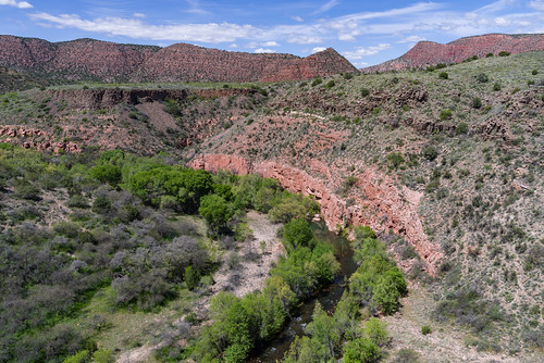
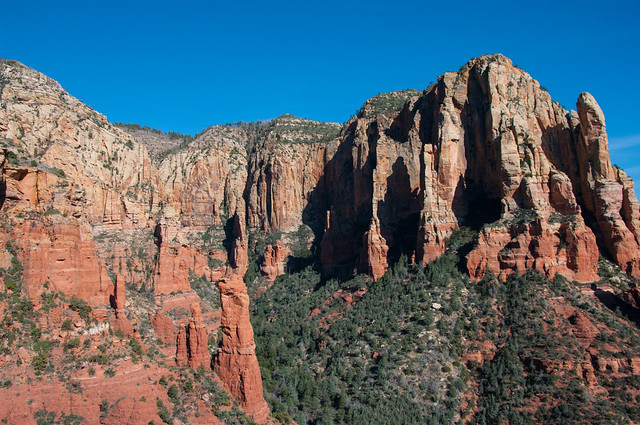
This collection of cliffs, buttes, and canyons has to rank as one of nature’s most magnificent masterpieces. It certainly is one of the most colorful. Red is the predominant hue here among these 43,950 acres of wind and water sculpted pinnacles, windows, arches, and slot canyons. The area is criss-crossed with trails that take you everywhere from the deepest gorges to the most prominent panoramas. Along these pleasant paths you’ll discover wonders made both by nature and by some of the area’s earliest human inhabitants. Watch the canyon walls and high cliffs for rock art and abandoned dwellings as diligently you keep an eye to the horizons for vistas and breathtaking overlooks.

As you part the chaparral to emerge into a hidden grotto or clamber up a slick rock slope to a dizzying precipice, you may even experience the unmatched thrill that you could have been the first to see whatever you’ve stumbled upon. One thing you’ll surely rediscover here among the manzanita and red rocks is your own sense of wonder.

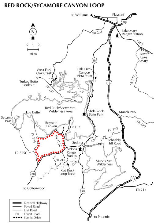
Trails in the Wilderness

All trails into the Wilderness start in the Red Rock Ranger District except Secret Mountain Trail #109, which is accessed from the Flagstaff Ranger District.

Additional Source: The Wilderness Institute.


Hover mouse over photo to display slideshow controls. View album on Flicker

Red Rock-Secret Mountain Wilderness


Directions

Location: 15 miles south of Flagstaff and just a few minutes from Sedona.

Access: You can get to this sprawling area from a number of highways and forest service roads. Major access points are off Route 66/FR 231, U.S. 89A and FR’s 152, 152D, 152C and 525.


Click map thumbnail for larger view.

Red Rock Secret Mountain Wilderness Map


GPS Coordinates

Latitude 0° 0′ 0.0000″ S

Longitude 0° 0′ 0.0000″ W

Categories
Uncategorized

Oak Creek Canyon Scenic Drive

Get your camera ready for this one, and don’t forget your swim suit, hiking shoes, and fishing pole. Just south of Flagstaff, Arizona State Route 89A descends a breathtaking series of switchbacks into a scenic, smaller cousin of the Grand Canyon. Known for colorful rocks and unique formations, Oak Creek Canyon is famous the world around for its spectacular scenery.

Before you drive into the canyon you’ll want to stop at Oak Creek Canyon Vista. Here you can get a bird’s eye view of what awaits you down the road and, at the same time, shop for Native American jewelry and other craft items from the local Native American artists who set up displays along the pathways.

Once you’ve snaked your way down the switchbacks, SR 89A winds a lazy course down the length of Oak Creek Canyon. It’s actually possible to enjoy the scenery here without leaving your car, but most people choose to get to know these crimson cliffs and crystal pools on a more personal basis. For that purpose there are plenty of overlooks, picnic areas, swimming holes and hiking trails all along the drive. At Midgely Bridge, there’s a vista point with an especially unforgettable backdrop where you’ll want to stop and use that wide-angle lens.

As you leave Oak Creek Canyon and continue past Sedona through Red Rock Country, an observer with a sharp eye will recognize familiar shapes among the natural sculptures that form the horizon. Keep an eye out for Steam Boat Rock, Courthouse Butte, Bell Rock and more.

You can continue down this scenic route to Interstate 17 and then back to Flagstaff, or you may want to turn around and do it all over again. If you’re driving a high clearance vehicle, another way to complete the loop is to return to I-17 via the unpaved, rocky Schnebly Hill Road rather than State Route 179. The vistas along this rocky but rewarding backroad are as good, if not better, than any along the rest of the drive. A high clearance vehicle is highly recommended for this route. In winter months, the upper part of Schnebly Hill Road is closed above Schnebly Hill Vista (near the top of the ascent up Bear Wallow Canyon), and the unpaved portion may be completely closed during wet weather conditions. Check Road Status before attempting this alternative route.

Attractions: Picnicking, waterplay, hiking, fishing, wildlife watching, photography

Road Condition: All roads (except alternative route up Schebly Hill Road) are paved and plowed, but may be slippery after a winter storm.

Driving Time: 2.5 hours or all day.

Directions

Location: Drive south from Flagstaff on AZ 89A 14 miles to Oak Creek Canyon Vista and then 13 miles more to Sedona. Turn east 11 miles on AZ 179 to I-17 and then 40 miles back to Flagstaff.


Click map thumbnail for larger view.

Oak Creek Scenic Drive Map


GPS Coordinates

Latitude 35° 1′ 40.9080″ N

Longitude 111° 44′ 2.7960″ W

Categories
Uncategorized

West Clear Creek Wilderness

Photo: looking into a canyon with green grass and patches of water at the bottom

In an isolated corner of the Coconino National Forest, Willow and Clover Creeks flow together to create West Clear Creek. Several writers have described this stream as one of the most remote and beautiful in the American Southwest. The canyon that the creek has cut into the southern edge of the Colorado Plateau is so deep and narrow that to proceed down it one is required to wade or swim as many as 15 to 20 pools that stretch from canyon wall to canyon wall. Some are as long as a quarter mile.

It goes without saying that any place this remote and inaccessible provides superior opportunities for solitude and primitive recreation. For most of its length the stream is a valuable fishing resource, too, and is stocked with trout by the Arizona Game and Fish Department. Trails leading into the canyon from the rim attract hardy adventurers seeking good fishing and secluded swimming holes. Trails that lead up from the canyon mouth get a lot of use by weekend anglers, picnickers, day hikers, and backpackers who use the primitive trailhead at the old Bull Pen Ranch.

Read more about West Clear Creek Wilderness.

The image above was taken overlooking the canyon just west of Hwy 87. This little slice of heaven is on the eastern end of West Clear Creek Wilderness.

The western portion of West Clear Creek is managed by the Red Rock Ranger District (928-203-2900). The eastern portion is managed by the Mogollon Rim Ranger District (928-477-2255). The District boundary runs north-south through the Home Take Draw area. 

Additional Source: The Wilderness Institute: West Clear Creek Wilderness

Directions

Location: 52 miles south of Flagstaff and 12 miles east of Camp Verde off paved and graveled roads some of which can be a bit rough.

Access: The lower areas of this remote canyon (Red Rock Ranger District) are accessible via a number of roads and trails, including FR 214 and FR 215 off FR 618 (see scenic drives). Upper reaches of the canyon (Mogollon Rim Ranger District) are accessible via the Maxwell Trail and Tramway Trail off FR 81 and FR 81E.

GPS (Bull Pen, Map): 34°32’22.0″N 111°42’31.6″W

Maps


Click map thumbnail for a larger view.

West Clear Creek Wilderness Map


GPS Coordinates

Latitude 0° 0′ 0.0000″ S

Longitude 0° 0′ 0.0000″ W

Categories
Uncategorized

Wet Beaver Creek

This clear, cool brook remains pleasantly secluded in the deep red rock canyon it has cut into the southern rim of the Colorado Plateau. For much of its length, the land bordering Wet Beaver Creek has been declared a Wilderness Area, the Wet Beaver Wilderness. In addition to the opportunities for solitude such an area offers, the stream’s pools and riffles are a popular place to fish, hike, swim, and bird watch. The waters of the stream are stocked with trout. The lush riparian area beside its banks is alive with a full palette of songbirds. The desert beyond that oasis bristles with the highly adapted plants of the upper Sonoran Desert.

Directions

Location: 45 miles south of Flagstaff on graveled Forest Roads in scenic rim country. Elevation is 3,800 feet.

Access: Drive south from Flagstaff on I-17 to the AZ Highway 179 exit. Leave the freeway here and drive 2 miles east on Forest Road 618 to the campground. FR 618 is graveled and suitable for sedans in most weather.

Maps


Click map thumbnail for larger view.

Wet Beaver Creek Map


GPS Coordinates

Latitude 0° 0′ 0.0000″ S

Longitude 0° 0′ 0.0000″ W

Categories
Uncategorized

Munds Mountain Wilderness

You can get to know Red Rock Country from top to bottom in the Munds Mountain Wilderness. This 18,150 acre area stretches from the tops of Munds and Lee mountains to the bottoms of Jacks, Woods, and Rattlesnake canyons. In the high country, you’ll enjoy views that stretch all the way from the floor of colorful Oak Creek Canyon to the top of the San Francisco Peaks, Arizona’s highest mountain. From the trails that traverse canyon floors, you’ll get an entirely different perspective on this area’s red rock magnificence, looking up at crimson canyon walls set against a deep blue Arizona sky.

The area is very convenient to the villages of Sedona and Oak Creek, extending right up to the edge of their posh resorts and galleries. Within this bit of suburban wilderness you’ll find two of the area’s most famous and most picturesque landmarks, Courthouse Butte and Bell Rock. Many people believe there is spiritual energy in these rocks, concentrated in centers they call vortexes. Whether you follow this spiritual belief or not, you’ll be one of a very few if you don’t experience your own energizing bliss among these picturesque formations.

A number of trails offer access to the wilderness. Two you may want to try are Jacks Canyon Trail and the Hot Loop Trail. Both lead from canyon bottom to high overlook. Quite likely you’ll have them to yourself, just you, the jackrabbits and the rest of the wildlife, that is.

Trails in Munds Mountain Wilderness

The following trails and areas are partially or completely inside the Wilderness.

Directions

Location: 30 miles south of Flagstaff off paved state highways and graveled Forest Roads.

Access: You won’t find it difficult to get to this wilderness, roads border it on three sides. Most popular access routes are: FR’s 153 (Schnebly Hill Road), 179F, 179, 793, and 647.

Maps

View an interactive visitor map of the Munds Mountain Wilderness.

  • Red Rock Recreation Guide [PDF]: Info on hiking, biking, camping, and more in Arizona’s magnificent Red Rock Country. Download the guide or pick one up at the Red Rock Ranger District Visitor Center.
  • The Digital Travel Map Whether you’re driving, hiking, riding, or exploring, you will find this full-color, GPS-enabled map a handy reference to have on your mobile device. The map show trails, recreation sites, major landmarks, and forest roads.
  • Forest Service Topo Map (FSTopo Geo-enable PDF)

Click map thumbnail for larger view.

Munds Mountain Wilderness Map


GPS Coordinates

Latitude 0° 0′ 0.0000″ S

Longitude 0° 0′ 0.0000″ W

Categories
Uncategorized

Red Rocks/Sycamore Canyon Loop Scenic Drive

This drive takes you into the heart of the magnificent Sedona Red Rock Country. The route hugs to the foot of those colorful cliffs and offers the option of four scenic side trips that lead to some of the most exciting features in Red Rock Country.

The Sterling Canyon Spur leads to two of the most spectacular rock formations in the area. Devil’s Bridge and Vultee Arch are each just a short hike off the road. The Boynton Canyon Spur leads to a trail into an area described as one of Sedona’s energy vortexes. The Loy Butte spur will put you in the middle of some of the area’s more sweeping vistas. The Sycamore Canyon Spur takes you past Robber’s Roost, where horse thieves once hid their contraband, and to Sycamore Pass, the gateway to the Sycamore Canyon Wilderness. Visiting every place on this list should put you at Red Rock Crossing at just about sunset. There, you can enjoy a bit of refreshment at one of the picnic tables before you join the chorus of photographers there to record one of the world’s most photographed scenes.

Length: About 23 miles, not counting spurs.

Season: All year although unpaved sections of the route may become muddy after storms.

Attractions: Red rocks galore, picnicking (primitive), hiking, biking, wildlife watching, photography

Driving Time: All day for the entire loop, but you may want to split it up into more manageable segments.

Note:

  • FR152C is now paved about one-half mile beyond the Doe/Bear Mountain trailheads, and the Red Rock Loop Road is paved except for the last mile or so. The rest of this route is unpaved and can become muddy and slippery when wet.
  • The Vultee Arch Spur (FR 152, Vultee Arch Road) is extremely rough. A high clearance vehicle is highly recommended. There is a large trailhead parking area near the beginning (paved portion) of the road. Devil’s Bridge is about a 1.5 mile hike from here (Chuckwagon Trail to Devil’s Bridge Trail).

Photos & Multimedia

Directions

Location: From Flagstaff drive south 29 miles on US 89A through Sedona to Dry Creek Road (FR 152C). Turn north and proceed along FR 152C for 2 miles to the Vultee Arch road and another 2.5 miles to the intersection with Boynton Canyon Road. FR 152C continues southwest left onto an unpaved road. In about 4 miles, FR 152C intersects FR 525. From here you can turn north (right) to the Loy Butte spur or south (left) to continue the drive. In another 4 miles FR 525 intersects FR 525C (Sycamore Pass spur). This road will take you to the East side of Sycamore Canyon. Continue south 5.5 miles to US 89A and another 5.3 miles on pavement back to Sedona. The Red Rock Loop Road (see photo), which accesses Red Rock Crossing and the Verde River, is located off US 89A about one mile south of Sedona.


Click map graphic for PRINTABLE view.

Red Rocks/Sycamore Canyon Loop Drive Map

GPS Coordinates

Latitude 0° 0′ 0.0000″ S

Longitude 0° 0′ 0.0000″ W

Categories
Uncategorized

West Clear Creek

The deep, rocky canyon cut by West Clear Creek, as it slices its way free of the Mogollon rim, is home to West Clear Creek Wilderness, one of the most unique Wilderness Areas in the Southwest. This gorge is so narrow that in places the stream fills it from wall to wall. To descend one has to swim or wade, not once but as many as 15 or 20 times. Lower reaches of the canyon are more accessible and provide excellent places for secluded recreation such as swimming, hiking, trout fishing, and wildlife watching. In addition to the many colorful birds in this area, it is home to some interesting larger creatures such as black bear, javelina, and mountain lion.

Campground Season: All year at Clear Creek Campground near Highway 260. Clear Creek Campground is open year-round.

Attractions: Fishing, camping, waterplay, sightseeing, wildlife viewing, photography

Facilities:

Directions

Location: 60 miles south of Flagstaff just off a paved State Highway 260. Elevation is 3,200 ft.

Access: Drive 50 miles south of Flagstaff on I-17, take any Camp Verde exit and head east through Camp Verde. Drive 6 miles on State Highway 260. Just past FR 618 is the Clear Creek Campground. Turn north to the campground.

Maps


Click map thumbnail for a larger view.

West Clear Creek Map


GPS Coordinates

Latitude 0° 0′ 0.0000″ S

Longitude 0° 0′ 0.0000″ W

Categories
Uncategorized

Lake Mary Recreation Corridor

The lakes are open year-round. In the warmer months (early May through early October), a fee is required to use the day-use areas, which are managed by a concessionaire. Vist individual sites for details and photos.

Upper Lake Mary is the largest of Flagstaff’s twin lakes. This long, narrow reservoir is especially popular with power boaters and water skiers because there is no motor size limit on it. It’s also popular with those who prefer people-power or windpower over horsepower. For those who like fishing, the lake has northern pike, channel cat, crappie, and some trout.

Lower Lake Mary is the smaller of Flagstaff’s twin lakes. It has a tendency to disappear during the long dry spells that periodically hit this area. When the lake has water, its banks are usually lined with anglers trying to catch the trout which the Arizona Game and Fish Department stocks here. If it stays full for a year or two, it will pick up a population of northern pike and catfish.

Picnic Areas

Campgrounds

Trails

There are several other lakes nearby, including Marshall, Ashurst, and Mormon lakes.


Hover mouse over photo to display slideshow controls. View album on Flicker

Lake Mary


Directions

Location: 7 to 17 miles southeast of Flagstaff on paved roads.

GPS (Map): 35°06’58.2″N 111°35’34.1″W (northwest end of Lower Lake Mary)

Access: Take Lake Mary Road (FH 3) south-east from Flagstaff. Lower Lake Mary is approximately 7 miles. The far end of Upper Lake Mary and Pinegrove Campground are approximately 17 miles. 


Click on map thumbnail for larger view.

Lower Lake Mary Map  Upper Lake Mary Map


GPS Coordinates

Latitude 35° 5′ 23.9712″ N

Longitude 111° 32′ 13.0236″ W

Categories
Uncategorized

Verde River

[photo] Verde River from Beasley Flats side on the Prescott NFThe Verde River is one of  Arizona’s only two Wild and Scenic Rivers, yet it remains relatively undiscovered as a recreational resource. That doesn’t mean this clear desert stream has little to offer. It’s an excellent place to fish for a number of species including trout, which the Arizona Game and Fish Department has begun stocking on a put and take basis. The Verde is also becoming more and more popular for recreational boating. Some stretches provide scenic canoeing among long pools and manageable riffles. Other sections become exciting whitewater runs during the spring snowmelt or after late summer thunderstorms.

There are several recreation sites and ways to access and enjoy the Verde River:

Hover mouse over image below to display slideshow controls. See Verde Wild & Scenic River photo album on Flickr.

Verde Wild & Scenic River


Directions

Location: 50 miles south of Flagstaff on paved and gravel roads. Elevation is a warm 3,000 feet.

Access: Drive south 50 miles from Flagstaff on I-17 to Camp Verde and turn east on State Highway 260 (the General Crook Highway). Major river access points are at the White Bridge where State Highway 260 crosses the river east of Camp Verde, at Beasley Flats via FR 574 and FR 529, and near the Childs Power Plant via FR 708 and FR 502. The route into Childs is steep and winding. It can become very soft and slippery when wet.

Verde River Coridor Map: This map covers from Tapco to Beasley Flat, and Hwy 89A to Sedona. It shows river access points, parks, campgrounds, and major roads in the area.


Verde River access points map (click thumbnail to view larger image)

Map of Verde River access points


GPS Coordinates

Latitude 0° 0′ 0.0000″ S

Longitude 0° 0′ 0.0000″ W

Categories
Uncategorized

Double Springs Campground


Double Springs Campground is an “old fashion” campground, originally built in the 1930’s, and has sites nestled in a beautiful draw filled with cool grass, ponderosa pine and Gambel oak. The heart of this camp is Double Spring, which runs to the surface just above camp. Wildlife and bird watching are popular activities in this area as they visit the spring. Some of the birds you may see are hawks, northern harriers, an occasional bald eagle and a variety of song birds. The area also boasts a healthy population of elk and mule deer.

Relax and take in the nostalgia of this historic campground or hike the Lake View Trail (2 miles one way), which originates at here. This trail leads to overlooks providing view of nearby Mormon Lake and the surrounding forests and volcanoes. Campground roads and parking spurs are gravel.

Trails lead from the campground to scenic overlooks of nearby Mormon Lake and the surrounding area of prairies, forests and volcanoes. Wildlife watching is also a popular activity in this area. It’s a very good place to see hawks, including northern harriers and ospreys. The area boasts a healthy population of elk and mule deer, too. The scenic village of Mormon Lake is conveniently close, offering horseback rides, mountain bike rentals. You’ll also find a country store, service station, and a picturesque cowboy steak house there.


Hover mouse over photo to display slideshow controls. View album on Flicker

Camping: Double Springs


Nearby Activities

  • Camping

Directions

Location: 24 miles south east of Flagstaff near Lake Mary. Elevation is7,000 feet.

GPS (Map): 34°56’32.6″N 111°29’36.9″W

Access: Drive south from Flagstaff 20 miles on Forest Highway 3 (Lake Mary Road) to the intersection of Forest Road 90. Turn west on FR 90 and drive 4.6 miles to Double Springs.

Click map thumbnail for larger view.

Map showing Dairy and Double Springs Campgrounds


GPS Coordinates

Latitude 34° 56′ 32.5680″ N

Longitude 111° 29′ 36.8880″ W