The vast West Clear Creek Wilderness is located on both the Red Rock District and the Mogollon Rim District. Click here for the main West Clear Creek Wilderness page.
Directions
GPS Coordinates
Latitude 0° 0′ 0.0000″ S
Longitude 0° 0′ 0.0000″ W
The vast West Clear Creek Wilderness is located on both the Red Rock District and the Mogollon Rim District. Click here for the main West Clear Creek Wilderness page.
Latitude 0° 0′ 0.0000″ S
Longitude 0° 0′ 0.0000″ W
South of Flagstaff, a collection of large and small lakes fill natural depressions in the area’s volcanic caprock. Plateau Country is popular with anglers, boaters, birdwatchers, campers, and hikers. It is also popular with photographers for the lakes serve as reflecting pools for the surrounding mountains and forests. During the appropriate seasons, birdwatchers and other wildlife enthusiasts come to take advantage of the annual waterfowl migrations and to observe rare bald eagles that spend the winter here fishing the open water of the surrounding lakes.
In the vicinity of Mormon Lake you may want to visit the picturesque little village along its western shore. This requires a short detour along FR 90 and FR 240. In the village you’ll find a lodge and restaurant, along with a number of rentable cabins. You can also rent a riding horse here, or a mountain bike or even cross country skis and snowmobiles in winter.
After leaving Forest Highway 3, the Plateau Lakes Scenic Drive takes you down a little traveled country road through meadows and forests where you’ll see vestiges of the area’s ranching heritage and perhaps catch a glimpse of some of its plentiful wildlife. The return trip is via Interstate 17 which features an excellent long distance view of the San Francisco Peaks.
Location: Drive south out of Flagstaff on Forest Highway 3 (Lake Mary Road) about 33 miles to Forest Road 213. Turn west 15 miles on FR 213 to I-17 and return 32 miles to Flagstaff.
Click on map image for printable view.

Latitude 0° 0′ 0.0000″ S
Longitude 0° 0′ 0.0000″ W
Marshall Lake is a small marshy body of water that’s generally full of coots and other waterfowl splashing, flapping, and cooting around. It is such valuable wildlife habitat that it is managed in partnership by Ducks Unlimited and the Arizona Game and Fish Department.
During most years the lake has enough water in it to be stocked with trout by the Arizona Game and Fish Department. In dry years, however, it may temporarily disappear! Even when the lake is dry this area still offers excellent opportunities for outdoor recreation.
Dry or wet, a number of primitive campsites near the east side of the lake provide exceptional views of the peaks from pine sheltered locations. The surrounding area also serves as a good place to come to see some of this area’s plentiful elk or its rare wintering bald eagles. The lake itself provides a hunting site for resident ospreys and a rest stop for migrating waterfowl.
Here is a 6-photo slide show. Click any image for full-size view.
Location: About 12 miles southeast of Flagstaff on paved and unpaved road.
GPS (Map): 35°06’44.6″N 111°32’18.4″W
Access: Drive 9 miles south from Flagstaff on Forest Highway 3 (Lake Mary Road). Turn east (left) on Forest Road 128 about 3 miles to the lake. The last mile or so is unpaved and may be impassable at times due to wet conditions. The road is closed in the winter.
Click on map thumbnail for larger view.

Latitude 35° 6′ 44.6328″ N
Longitude 111° 32′ 18.3912″ W
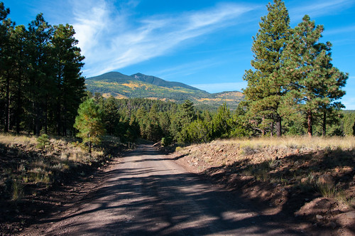
This drive takes you all the way around Arizona’s highest mountain, winding through a land of pine forests and aspen groves, open prairies and rustic homesteads. Anytime is a good time to enjoy this drive, although the roads are closed through much of the winter (you might want to ski or snowmobile it then).
In the spring, wildflowers follow the retreating snow up the mountain. They color the meadows and decorate the forests reaching a climax just as summer comes to a close. Autumn then turns the mountain to gold, filling forest roads and trails with visitors come to enjoy the colorful display.
There are a number of places along this route where you can stop to take a hike, enjoy a lunch or even set up a primitive camp. That way you can take more than one day to do this drive or combine it with one or more of the other scenic drives in the vicinity of the San Francisco Peaks.
Click on an image for full size view.
Location: From the heart of Flagstaff, drive northeast about 15 miles on US 89 until you see a “Forest Access” sign at mile marker 430.4 directing you to turn left (west). (See photos for directions – click on “Photos & Multimedia” in the right column..)
Once you cross US 89, you will enter FR 552 which will come to a “T” about a half mile down the road. Following FR 552, turn right (north) to head towards FR 418.
After driving for about a mile, you will see a sign that directs you to take another right on to FR 418.
Follow FR 418 approximately 12 miles to FR 151 where you can either go right or left. If you go right on FR 151, it’s only a couple of miles until you get to US 180. If you decide to go left on FR 151, it’s about 8 miles to US 180, but this section of the drive is very beautiful and cuts between Hart Prairie and Snowbowl.
Click map thumbnail for a larger view.

Latitude 0° 0′ 0.0000″ S
Longitude 0° 0′ 0.0000″ W
Pumphouse Wash (Forest Road 237) is a popular dispersed camping area in the ponderosa pine forest along SR 89A, midway between Flagstaff and Sedona, Arizona. The area is conveniently located near Oak Creek Canyon, Sedona, Flagstaff, Woody Mountain Road, Lake Mary, and a variety of recreation sites. It is a popular alternative to traditional campgrounds for visitors to Oak Creek Canyon and the Flagstaff area.
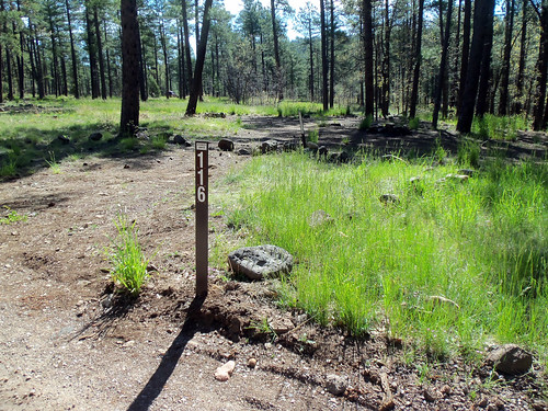
There are four campsite loops, each containing between 11 and 26 signed and numbered sites. The site offers excellent camping opportunities for large groups as well as families and individuals. Most sites offer partial to full shade beneath towering ponderosa pine trees, and are generally flat, making it easy to set up tents or campers. Each site has parking and a campfire ring. There is no trash service, so if you pack it in, pack it out. There are no restroom facilities. Portable toilets are highly recommended.
FR 237 and the camping loop roads are well maintained and suitable for passenger cars.
Photo tour from this site [Flickr].
Location: Pumphouse Wash area 11 miles south of Flagstaff, 5 miles north of Oak Creek Canyon, and 18 miles north of Sedona.
Access:
GPS (Map): 35°03’15.5″N 111°43’35.1″W
Maps
FR 237 Dispersed Camping Map and Guide (PDF, 910 kB)

Latitude 35° 3′ 15.3324″ N
Longitude 111° 43′ 35.1696″ W
 Make your way to Arizona Nordic Village during the most magical time of the year, winter! With over 40 kilometers of trails specifically groomed for cross-country skiing and separate trails packed for snowshoeing and fat tire biking, you are sure to have an unforgettable experience. To add to your experience book an overnight stay in one of our cabins or yurts and ski yourself and your gear out with you! Front country yurts are located 100 feet from the parking lot, back country cabins and yurts range from 0.5 miles to 3 miles from the parking lot. Vehicles are prohibited on the trail systems. The winter season at Arizona Nordic Village usually begins mid-December and ends in March each year.
Visit the Arizona Nordic Village website for detailed information, lodging reservations, and event bookings. See Winter Recreation Map and Information for more about winter sports and snowplay in the Flagstaff area.
See Arizona Nordic Village in the Summer for information about hiking, group events, and other summertime activities.
Location: 16 miles north of Flagstaff on paved and plowed roads. Elevation is 8,000 feet.
GPS (Map): 35°22’00.9″N 111°47’24.4″W
Access: Drive 16 miles north from Flagstaff on US 180 and look for the Arizonan Nordic Village signs at mile marker 232.
Click on map thumbnail for a larger view.

 See our Winter Recreation page for a recreation map, backcountry permit information, and more info!
Flagstaff Winter Recreation Hotline (Flagstaff CVB)
1-844-256-SNOW (7669)
Latitude 35° 22′ 0.5268″ N
Longitude 111° 47′ 28.8960″ W
 A primarily roadless and Wilderness hunt area designated to help restore aspen, in particular young aspen sprouts that are browsed upon by elk and deer. It’s ideal for those seeking a unique and challenging hunt on foot or horseback.
The Coconino National Forest and Arizona Game & Fish Department (AZGFD) teamed-up to create this new AZGFD sub-unit. The Peaks Hunt is Game Management Unit 11M and was first established in 2011. It has since become a popular hunt with above average success even though it is listed as a “Limited Opportunity” hunt area.
The unit includes the San Francisco Peaks and Hart Prairie – some of the most scenic areas on the forest and the highest elevation in Arizona. The 1996 Hochderffer Fire (pictured here) and 2010 Schultz Fire burn scars are also within the unit boundary.
Latitude 0° 0′ 0.0000″ S
Longitude 0° 0′ 0.0000″ W
This clear canyon stream may be one of the most scenic fishing and swimming holes in the world. Oak Creek flows through Oak Creek Canyon, a narrow gorge it has cut along a fault line in the same rock strata that form the Grand Canyon. But this smaller cousin of the world’s most prestigious chasm, is much more accessible than its more famous relative. A road leads right down the middle of it. And if you’d really like to get to know these crimson cliffs and crystal pools up close and personal, there are plenty of overlooks and picnic areas, hiking trails and creekside paths to help you do it.
In Oak Creek Canyon, be sure to stop by the Oak Creek Visitor Center at Indian Gardens when it opens for the season, or visit the Red Rock Ranger District Visitor Center near the Village of Oak Creek year-round.
There is a catch and release section along Oak Creek from Call of the Canyon downstream to Junipine Resort. Refer to Arizona Game and Fish fishing regulations for details.
Campgrounds usually fill early. The best opportunities for getting a campsite are weekday mornings between 8 a.m. and 11 a.m., or make reservations where available.
Location: The top of Oak Creek is 14 miles south of Flagstaff on paved roads. Elevation is around 5,000 feet, dropping as Oak Creek flows down the canyon and through the Sedona area.
Access: Drive south from Flagstaff on Hwy. 89A. 14 miles down the road it drops nearly a thousand feet down a series of switchbacks to the canyon floor and continues for 13 more miles alongside Oak Creek in Oak Creek Canyon. The creek exits the canyon into Sedona, passing by Cathedral Rock and Red Rock Crossing on its meandering way southwest to its confluence with the Verde River southeast of Cottonwood.
Click map thumbnail for a larger view.
Latitude 35° 1′ 40.9080″ N
Longitude 111° 44′ 2.7960″ W

This tucked away desert oasis is the smallest of four major canyons that cut the Coconino National Forest’s red rock rim country. Though it may be small, the scenery you’ll find here is none the less impressive. Much of the narrow steep-sided gorge Wet Beaver Creek Canyon has carved into the Colorado Plateau’s southern face is quite remote and few people venture into its inner depths. The easiest access is upstream from the canyon mouth along a well used hiking trail. Even in this case reaching the gorge’s more remote upper stretches is no easy task. Continuing upstream beyond where the Bell Trail climbs out of the canyon and out of the wilderness requires swimming or wading a number of coldwater pools which stretch from wall to canyon wall.

Most of those who come here confine their visit to the area’s lower, more accessible reaches which provide a popular place to swim, fish, camp and hike in a picturesque, setting. Others venture upstream of Bell Crossing where the solitude deepens as you venture farther from this area’s more popular haunts.
Location: 43 miles south of Flagstaff on graveled Forest Roads suitable for passenger vehicles in most weather.
Access: Wet Beaver Creek Canyon is most accessible from FR 618 off Interstate 17 45 miles south of Flagstaff. Upstream access is possible south of the Apache Maid Lookout Tower from FR 213 and FR 229 off I-17 at the Stoneman Lake Exit.
Click map thumbnail for larger view.
Latitude 0° 0′ 0.0000″ S
Longitude 0° 0′ 0.0000″ W
This is a drive through scenic desert country where you’ll see colorful canyons, lush oases, picturesque ranches, and out of the way Indian ruins. The route skirts the lower elevations of Arizona’s rim country where red rock canyons spill out from under thick basalt flows. The road cuts two of these canyons and offers access to a third along the way.
Roadside signs point the way to a number of hiking trails and a few spur roads leading off into the backcountry.
There is a picnic area at Wet Beaver Creek Crossing (Beaver Creek Day Use Area) and another along West Clear Creek (Clear Creek Campground) at route’s end. A primitive road leads to an undeveloped campground and recreation area at the mouth of West Clear Creek Canyon. A short side trip leads to Montezuma’s Well National Monument, a large spring surrounded by cultural sites.
Keep an eye out for road runners, coyotes and javelinas as you drive. The road is a bit rough, but if you go slow it’s not too bad.
Attractions: Sightseeing, History (ruins and ranches), Camping/picnicking, Swimming/wading, Fishing, Hiking, Mtn. biking, Wildlife watching
Road Condition: FR 618 is graveled and suitable for passenger cars; however, it can become soft and slippery when wet. FH 9 is paved.
Driving Time: 3.5 hours or all day
Photo (above): viewof Wet Beaver Creek from Bell Trail, one of the many sights and activities to enjoy along the Desert Canyon Loop. USFS/Deborah Lee Soltesz (2008)
Location: Drive 45 miles south from Flagstaff on I-17 to the AZ 179 exit. Turn east, under the highway onto FR 618. Follow this road along the base of the Mogollon Rim 13 miles to FH 9 (the General Crook Road) and turn west (right) 9 miles back to I-17. It’s 60 miles back to Flagstaff.
Click map graphic for PRINTABLE view.
Latitude 0° 0′ 0.0000″ S
Longitude 0° 0′ 0.0000″ W