Categories
Uncategorized

MEYERS CREEK CABIN

Overview

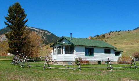
Meyers Creek Cabin is located within the Meyers Creek Work Center in Custer National Forest at an altitude of 5,646 feet. The cabin offers opportunities to enjoy relaxation and recreation in beautiful surroundings. It is reservable from May through November.

The cabin is accessible by vehicle. 4-wheel drive is recommended during wet weather.

Recreation

Trails crisscross the area, including the Meyers Creek and Lodgepole Creek Trails. This area offers recreation for hikers, mountain bikers and equestrians. Horse facilities are available at the cabin.

Anglers can fish for rainbow and brown trout in nearby creeks.

Facilities

This cabin sleeps 6 people and comes equipped with 5 single mattresses, an electric refrigerator, cook stove, heat, indoor toilet and shower, cookware, dishes and
utensils. A campfire ring is located outside.

There are 2 corrals, a watering tank and hitching rails for horses. Potable water is available, but guests may wish to bring a water filter or provide their own water
if they are concerned about quality or taste.

Items such as bedding, towels, washcloths and dish soap are not provided.

Natural Features

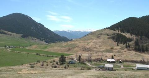
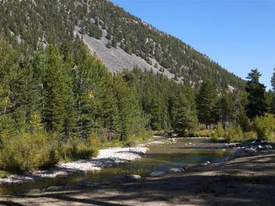
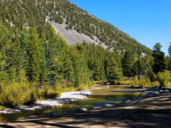
The cabin is situated in the western end of the Beartooth Mountains and surrounded by pastures, which are used for grazing cattle. Roses, irises, rhubarb and lilacs grow around the dwelling. The surrounding slopes are covered in pine, aspen and sagebrush, with wildflowers blooming in the summer.

This area supports a large bear population ( bear safety ). Bighorn sheep, elk, deer and a variety of bird species also inhabit the mountainous terrain in the Beartooth Ranger District.

Nearby Attractions

The Stillwater River Trailhead, with access to the Absaroka/Beartooth Wilderness, is 16 miles south of the cabin.

Nearby Activities

  • Biking
  • Camping
  • Fishing
  • Hiking
  • Horseback riding
  • Wildlife viewing

Gallery

Directions

From the north, take State Highway 78 through Absarokee,
Montana, to junction with State Highway 419 3 miles south of Absarokee.
Turn right (west) and follow State Highway 419 for 21 miles to Nye.
Turn right (north), following the directional sign for 1 mile. Turn left
(west) at "Y" intersection and travel approximately 5 miles. Turn right
(north) at Meyers Creek/Picket Pin Road intersection and follow road for
2 miles, turning left into Meyers Creek Work Center.

From the south, take State Highway 78 from Red Lodge, Montana,
to junction with State Highway 419 3 miles south of Absarokee. Turn
right (west) and follow State Highway 419 for 21 miles to Nye, MT. Turn
right (north), following the directional sign for 1 mile. Turn left (west)
at "Y" intersection and travel approximately 5 miles. Turn right
(north) at Meyers Creek/Picket Pin Road intersection and follow road for
2 miles. Turn left into Meyers Creek Work Center.

GPS Coordinates

Latitude 45° 29′ 30.0001″ N

Longitude 109° 57′ 29.9999″ W

Categories
Uncategorized

CASCADE

Overview

Cascade Campground is located 11 miles west of Red Lodge, in southern Montana. It conveniently sits along Forest Road 2071, which is paved for most of the route. The area is a popular location for hiking, backpacking and fishing.

The administering organization is Gallatin Canyon Campgrounds; e-mail: gccampgrounds13@gmail.com

Recreation

Fishing is a popular activity along the West Fork of Rock Creek and at nearby Wild Bill Lake. The small lake is open to kayaking and canoeing, and an accessible fishing dock is located on the shore.

The Basin Lakes Trailhead is three miles away, across the road from Basin Campground. Silver Run Plateau, West Fork and Timberline Lakes trails offer access to the Absaroka-Beartooth Wilderness.

Mountain bikers enjoy the Ingles Creek Trail and a variety of loop trails at Silver Run. Biking is also allowed on the Basin Lakes Trail.

Facilities

The campground offers several single-family sites, two of which are accessible. Each site is equipped with a picnic table and campfire ring with grill. Accessible vault toilets and drinking water are provided. Trash may be deposited in receptacles at nearby Basin Campground.

Sites 1 and 2 support established accessibility standards.

Natural Features

The campground is situated on the banks of the West Fork of Rock Creek. The area surrounding the campground was burned by the Cascade Fire in 2008, which left many open glades with abundant wildflowers.

Nearby Attractions

The charming town of Red Lodge, Mont., offers a variety of dining and lodging options, galleries, shops and annual summer events. The Home of Champions Rodeo is held on the Fourth of July weekend, Beartooth Bike Rally and Iron Horse Rodeo take place in mid-July, the Mountain Man Rendezvous is in late July and the Festival of Nations happens in early August.

The Beartooth Highway was deemed “the most beautiful drive in America,” by the late Charles Kuralt. It snakes across the rugged Beartooth Mountains from Red Lodge to Cooke City. It is the highest elevation highway in the Northern Rockies. Along the way, visitors are treated to sweeping views and plentiful opportunities for outdoor recreation.

Charges & Cancellations

Refunds: Refund requests made through www.recreation.gov will be charged a $10 processing fee. This cancellation processing fee is retained by the reservation service contractor along with the non-refundable reservation fee. All requests for the return of the non-refundable reservation fee and the cancellation processing fee will be declined by the campground concessionaire as they did not receive these fees (these are the fees retained by the reservation contractor, a different entity).

Nearby Activities

  • Biking
  • Boating
  • Fishing
  • Hiking
  • Wildlife viewing
  • Kayaking
  • Canoeing

Gallery

Directions

From U.S. Highway 212, go to the south end of Red Lodge. Turn west onto West Fork Rock Creek Road (Forest Road 2071) and travel 11 miles west. The campground is on the left.

GPS Coordinates

Latitude 45° 10′ 23.9999″ N

Longitude 109° 27′ 2.9999″ W

Categories
Uncategorized

WOODBINE CAMPGROUND

Overview

Woodbine Campground is remotely located adjacent to the Absaroka-Beartooth Wilderness in southwestern Montana, about three hours from Yellowstone National Park via the scenic Beartooth Highway. Red Lodge, Montana is 57 miles east; Nye is 7 miles north.

The administering organization is Gallatin Canyon Campgrounds; e-mail: gccampgrounds13@gmail.com

Recreation

The Stillwater River and nearby streams and lakes offer great fishing opportunities for rainbow, brown and cutthroat trout.

Hiking the Woodbine Falls Trail is a popular activity among campers. The 1.5-mile round-trip trail begins in the campground and follows Woodbine Creek before ending at an impressive cascade.

The Stillwater Trail provides access to the Absaroka-Beartooth Wilderness and is open to hiking and horseback riding. The trail reaches beautiful Sioux Charley Lake after 3 miles and continues on another 20+ miles into the wilderness.

Facilities

The campground offers single and group sites, some of which are accessible. Picnic tables and campfire rings with grills are provided, as are accessible vault toilets and drinking water.

Natural Features

Woodbine Campground is situated on the banks of the Stillwater River at an elevation of 5,300 feet. The campground is wooded and shady, with views of the surrounding snow-covered, 10,000 foot peaks.

A variety of wildlife, including deer, elk and bear, can be found in the surrounding area, creating prime opportunities for wildlife viewing.

Nearby Attractions

The Absarokee-Beartooth Wilderness Area is adjacent, boasting 700 miles of trails and hundreds of alpine lakes. The wilderness borders Yellowstone National Park and is a part of the 20-million-acre Greater Yellowstone Ecosystem.

The nearby town of Nye hosts Nye Goes Nuts annually in July. The popular event includes food, drinks, children’s games and the chicken chase, a crowd favorite.

The small community of Fishtail holds its annual Fishtail Family Fun Day at the end of June, with a pancake breakfast, vendor booths, a parade and live music.

Nearby Activities

  • Biking
  • Camping
  • Fishing
  • Hiking
  • Wildlife viewing

Gallery

Directions

Take Montana Highways 78 and 419 south of Columbus (on 1-90) 43 miles west of Billings, Montana.

GPS Coordinates

Latitude 45° 21′ 7.9999″ N

Longitude 109° 53′ 47.0000″ W

Categories
Uncategorized

SHERIDAN

Overview

Sheridan Campground is located seven miles south of Red Lodge, in southern Montana. It is just off the scenic Beartooth Highway. The area is a popular location for fishing, hiking and scenic driving.

The administering organization is Gallatin Canyon Campgrounds; e-mail: gccampgrounds13@gmail.com

Recreation

The Main Fork of Rock Creek offers rainbow trout fishing. Greenough Lake is eight miles away, and is a popular area for canoeing, kayaking and fishing.

The Beartooth Wilderness can be accessed via the Hellroaring and Lake Fork trailheads, both nearby. Beartrack and Corral Creek trailheads are not far from the campground as well. Visitors also enjoy mountain biking and hiking on the Parkside National Recreation Trail. Hellroaring Road is open to off-road vehicles.

Facilities

This small campground offers single-family sites. Picnic tables and campfire rings with grills are provided, as are accessible vault toilets and drinking water.

Sites 5 through 8 are 30 feet in length or less; the turnaround is tight for trailers and RVs. Campsites 1 and 2 are level and suitable for those with limited mobility but do no fully meet accessibility standards, while site 9 supports established accessibility standards.

Natural Features

The campground sits in the shadow of the Beartooth Range, on the banks of Rock Creek. A forest of aspen and pine covers the area. A variety of wildlife, including grizzly bear, deer and elk, makes its home in the surrounding area.

Nearby Attractions

The charming town of Red Lodge, Mont., offers a variety of dining and lodging options, galleries, shops and annual summer events. The Home of Champions Rodeo is held on the Fourth of July weekend, Beartooth Bike Rally and the Iron Horse Rodeo take place in mid-July, the Mountain Man Rendezvous occurs in late July, and the Festival of Nations is in early August.

The Beartooth Highway was deemed “the most beautiful drive in America,” by the late Charles Kuralt. It snakes across the rugged Beartooth Mountains from Red Lodge to Cooke City. It is the highest elevation highway in the Northern Rockies. Along the way, visitors are treated to sweeping views and plentiful opportunities for outdoor recreation.

Yellowstone National Park’s northeast entrance is 60 miles from the campground, via the Beartooth Highway. The park offers unparalleled wildlife viewing opportunities, as well as breathtaking scenery and unique geological features.

Charges & Cancellations

Refunds: Refund requests made through www.recreation.gov will be charged a $10 processing fee. This cancellation processing fee is retained by the reservation service contractor along with the non-refundable reservation fee. All requests for the return of the non-refundable reservation fee and the cancellation processing fee will be declined by the campground concessionaire as they did not receive these fees (these are the fees retained by the reservation contractor, a different entity).

Nearby Activities

  • Biking
  • Boating
  • Camping
  • Fishing
  • Hiking

Gallery

Directions

From U.S. Highway 212, turn off at Eastside Road and go 2 miles to the campground. The entrance is on the left.

GPS Coordinates

Latitude 45° 6′ 5.0000″ N

Longitude 109° 18′ 7.9999″ W

Categories
Uncategorized

RATTIN CAMPGROUND

Overview

Rattin Campground is located 7 miles south of Red Lodge, Montana, just off the scenic Beartooth Highway. The area is a popular location for fishing, hiking and scenic driving.

The administering organization is Gallatin Canyon Campgrounds; e-mail: gccampgrounds13@gmail.com

Recreation

The Main Fork of Rock Creek offers rainbow trout fishing. Greenough Lake is 8 miles away and is a popular area for canoeing, kayaking and fishing.

The Beartooth Wilderness can be accessed via the Hellroaring and Lake Fork Trailheads, both of which are nearby. Beartrack and Corral Creek Trailheads are close by as well.

Visitors also enjoy mountain biking and hiking on the Parkside National Recreation Trail. Hellroaring Road is open to off-road vehicles.

Facilities

This small campground offers single-family sites. Picnic tables and campfire rings with grills are provided, as are accessible vault toilets and drinking water.

Natural Features

The campground sits in the shadow of the Beartooth Range on the banks of Rock Creek. A forest of aspen and pine covers the area. A variety of wildlife, including grizzly bear, deer and elk, make their home in the surrounding area.

Nearby Attractions

The charming town of Red Lodge, Montana offers a variety of dining and lodging options, galleries, shops and summer events. The Home of Champions Rodeo is held on the Fourth of July weekend, Beartooth Bike Rally and Iron Horse Rodeo in mid-July, Mountain Man Rendezvous in late July and the Festival of Nations in early August.

The Beartooth Highway was deemed “the most beautiful drive in America” by the late Charles Kuralt. It snakes across the rugged Beartooth Mountains from Red Lodge to Cooke City, Montana, and is the highest elevation highway in the Northern Rockies. Along the way, visitors are treated to sweeping views and plentiful outdoor recreation opportunities.

Yellowstone National Park’s Northeast Entrance is 60 miles from the campground via the Beartooth Highway. The park offers unparalleled wildlife viewing opportunities, as well as breathtaking scenery and unique geological features.

Charges & Cancellations

Refunds: Refund requests made through www.recreation.gov will be charged a $10 processing fee. This cancellation processing fee is retained by the reservation service contractor along with the non-refundable reservation fee. All requests for the return of the non-refundable reservation fee and the cancellation processing fee will be declined by the campground concessionaire as they did not receive these fees (these are the fees retained by the reservation contractor, a different entity).

Nearby Activities

  • Biking
  • Fishing
  • Hiking
  • Wildlife viewing
  • Hotel/lodge/resort privately owned
  • Off road vehicle trails
  • Non-motorized boating
  • Scenic drive

Gallery

Directions

Rattin Campground is located 60 miles northeast of Cooke City, MT and the northeast gate to Yellowstone National Park. It is 7 miles south of Red Lodge, MT. On U.S. Highway 212, turn off at Rattin Campground Road (Forest Road 379; formerly Eastside Road) and proceed 0.5 miles to the campground entrance on the left.

GPS Coordinates

Latitude 45° 4′ 59.0002″ N

Longitude 109° 18′ 0.0000″ W

Categories
Uncategorized

PARKSIDE

Overview

Parkside Campground is located 12 miles south of Red Lodge, Montana, just off the scenic Beartooth Highway.
The area is a popular location for fishing, hiking and scenic driving. Greenough Lake less than a mile away. Glacier Lake, Hellroaring and Lake Fork Trailheads are nearby.

The administering organization is Gallatin Canyon Campgrounds; e-mail: gccampgrounds13@gmail.com

Recreation

The Main Fork of Rock Creek and nearby 5-acre Greenough Lake offer rainbow trout fishing. The lake is also open to canoeing and kayaking.

The Beartooth Wilderness can be accessed via the Hellroaring and Lake Fork Trailheads, both nearby. Visitors also enjoy mountain biking and hiking on the Parkside National Recreation Trail. Hellroaring Road is open to off-road vehicles.

Facilities

The campground offers two group sites and several single-family sites, three of which are accessible. Picnic tables and campfire rings are provided, as are accessible vault toilets and drinking water. Trash can be deposited at the Greenough Lake Campground.

Natural Features

The campground sits in the shadow of the Beartooth Range on the banks of Rock Creek. A forest of aspen and pine covers the area. A variety of wildlife, including grizzly bear, deer and elk, make their home in the surrounding area.

Nearby Attractions

The charming town of Red Lodge, Montana offers a variety of dining and lodging options, galleries, shops and summer events. The Home of Champions Rodeo is held on the Fourth of July weekend, Beartooth Bike Rally and Iron Horse Rodeo in mid-July, Mountain Man Rendezvous in late July and the Festival of Nations in early August.

The Beartooth Highway was deemed “the most beautiful drive in America” by the late Charles Kuralt. It snakes across the rugged Beartooth Mountains from Red Lodge to Cooke City, Montana, and is the highest elevation highway in the Northern Rockies. Along the way, visitors are treated to sweeping views and plentiful outdoor recreation opportunities.

Yellowstone National Park’s Northeast Entrance is 55 miles from the campground via the Beartooth Highway. The park offers unparalleled wildlife viewing opportunities, as well as breathtaking scenery and unique geological features.

Charges & Cancellations

Refunds: Refund requests made through www.recreation.gov will be charged a $10 processing fee. This cancellation processing fee is retained by the reservation service contractor along with the non-refundable reservation fee. All requests for the return of the non-refundable reservation fee and the cancellation processing fee will be declined by the campground concessionaire as they did not receive these fees (these are the fees retained by the reservation contractor, a different entity).

Nearby Activities

  • Biking
  • Boating
  • Camping
  • Fishing
  • Hiking

Gallery

Directions

From U.S. Highway 212, turn off at Rock Creek Road (Forest Road 2421). Go 0.3 miles to the campground entrance on the right.

GPS Coordinates

Latitude 45° 3′ 42.9998″ N

Longitude 109° 24′ 32.0000″ W

Categories
Uncategorized

LIMBER PINE

Overview

Limber Pine Campground is located 12 miles south of Red Lodge, in southern Montana. It is just off the scenic Beartooth Highway. The area is a popular location for fishing, hiking and scenic driving. Greenough Lake is a half-mile away. Glacier Lake, Hellroaring and Lake Fork trailheads are nearby.

The administering organization is Gallatin Canyon Campgrounds; e-mail: gccampgrounds13@gmail.com

Recreation

The Main Fork of Rock Creek and nearby 5-acre Greenough Lake offer rainbow trout fishing. The lake is also open to canoeing and kayaking.

The Beartooth Wilderness can be accessed nearby, via the Hellroaring and Lake Fork trailheads. Visitors also enjoy mountain biking and hiking on the Parkside National Recreation Trail. Hellroaring Road is open to off-road vehicles.

Facilities

The campground offers single-family campsites. Each site is equipped with a picnic table and campfire ring. Accessible vault toilets and hand-pumped drinking water are provided. Trash can be deposited in receptacles at the Greenough Lake Campground.

Natural Features

The campground sits in the shadow of the Beartooth Range on the banks of Rock Creek. A forest of aspen and pine covers the area. A variety of wildlife, including grizzly bears, deer and elk, makes its home in the surrounding area.

Nearby Attractions

The charming town of Red Lodge, Mont., offers a variety of dining and lodging options, galleries, shops and annual summer events. The Home of Champions Rodeo is held on Fourth of July weekend, Beartooth Bike Rally and Iron Horse Rodeo take place in mid-July, the Mountain Man Rendezvous is in late July and the Festival of Nations happens in early August.

The Beartooth Highway was deemed “the most beautiful drive in America,” by the late Charles Kuralt. It snakes across the rugged Beartooth Mountains from Red Lodge to Cooke City. It is the highest elevation highway in the Northern Rockies. Along the way, visitors are treated to sweeping views and plentiful opportunities for outdoor recreation.

Yellowstone National Park’s northeast entrance is 55 miles from the campground, via the Beartooth Highway. The park offers unparalleled wildlife viewing opportunities, as well as breathtaking scenery and unique geological features.

Charges & Cancellations

Refunds: Refund requests made through www.recreation.gov will be charged a $10 processing fee. This cancellation processing fee is retained by the reservation service contractor along with the non-refundable reservation fee. All requests for the return of the non-refundable reservation fee and the cancellation processing fee will be declined by the campground concessionaire as they did not receive these fees (these are the fees retained by the reservation contractor, a different entity).

Nearby Activities

  • Fishing
  • Hiking
  • Off road vehicle trails
  • Kayaking
  • Canoeing

Gallery

Directions

From U.S. Highway 212, turn off at Rock Creek Road (Forest Road 2421). Go just over a mile to the campground entrance, which should be on the left.

GPS Coordinates

Latitude 45° 3′ 29.9999″ N

Longitude 109° 24′ 43.9999″ W

Categories
Uncategorized

GREENOUGH LAKE

Overview

Greenough Lake Campground is within walking distance of its namesake, 12 miles south of Red Lodge, in southern Montana. It is located just off the scenic Beartooth Highway. The area is a popular location for fishing, hiking and scenic driving. Glacier Lake, Hellroaring and Lake Fork trailheads are nearby.

The administering organization is Gallatin Canyon Campgrounds; e-mail: gccampgrounds13@gmail.com

Recreation

Greenough Lake offers canoeing, kayaking and rainbow trout fishing. The Main Fork of Rock Creek is also a popular fishing stream.

The Beartooth Wilderness can be accessed via the Hellroaring and Lake Fork trailheads, both of which are not far from the campground. Visitors also enjoy mountain biking and hiking on the Parkside National Recreation Trail. Hellroaring Road is open to off-road vehicles.

Facilities

The campground offers single-family campsites, two of which are accessible. Each site is equipped with a picnic table and campfire ring. Accessible vault toilets and hand-pumped drinking water are provided.

Natural Features

The campground sits in the shadow of the Beartooth Range, on the banks of Rock Creek, less than a quarter-mile from beautiful Greenough Lake. A forest of aspen and pine trees covers the area. A variety of wildlife, including grizzly bears, deer and elk, makes its home in the surrounding area.

Nearby Attractions

The charming town of Red Lodge, Mont., offers a variety of dining and lodging options, galleries, shops and annual summer events. The Home of Champions Rodeo is held on the Fourth of July weekend, the Beartooth Bike Rally and Iron Horse Rodeo take place in mid-July, the Mountain Man Rendezvous is in late July, and the Festival of Nations happens in early August.

The Beartooth Highway was deemed “the most beautiful drive in America,” by the late Charles Kuralt. It snakes across the rugged Beartooth Mountains from Red Lodge to Cooke City. It is the highest elevation highway in the Northern Rockies. Along the way, visitors are treated to sweeping views and plentiful opportunities for outdoor recreation.

Yellowstone National Park’s northeast entrance is 55 miles from the campground, via the Beartooth Highway. The park offers unparalleled wildlife viewing opportunities, as well as breathtaking scenery and unique geological features.

Charges & Cancellations

Refunds: Refund requests made through www.recreation.gov will be charged a $10 processing fee. This cancellation processing fee is retained by the reservation service contractor along with the non-refundable reservation fee. All requests for the return of the non-refundable reservation fee and the cancellation processing fee will be declined by the campground concessionaire as they did not receive these fees (these are the fees retained by the reservation contractor, a different entity).

Nearby Activities

  • Biking
  • Boating
  • Camping
  • Fishing
  • Hiking
  • Off road vehicle trails
  • Kayaking
  • Canoeing
  • Scenic drive

Gallery

Directions

From U.S. Highway 212, turn off at Rock Creek Road (Forest Road 2421). Go 1 mile to campground entrance, which is on the left.

GPS Coordinates

Latitude 45° 3′ 22.0000″ N

Longitude 109° 24′ 46.0001″ W

Categories
Uncategorized

BASIN MONTANA CAMPGROUND

Overview

Basin Campground is located 7 miles west of Red Lodge, Montana, along Forest Road 2071, which is paved all the way to the campground. The area is a popular location for hiking, backpacking and fishing.

The administering organization is Gallatin Canyon Campgrounds; e-mail: gccampgrounds13@gmail.com

Recreation

Fishing is a popular activity along the West Fork of Rock Creek and at nearby Wild Bill Lake. The small lake is open to kayaking and canoeing, and an accessible fishing dock is located on the shore.

The Basin Lakes Trailhead is just across the road. Silver Run Plateau, West Fork and Timberline Lakes Trails offer access to the Absaroka-Beartooth Wilderness.

Mountain bikers enjoy the Ingles Creek Trail and a variety of loop trails at Silver Run. Biking is also allowed on the Basin Lakes Trail.

Facilities

The campground offers several single-family sites, three of which are accessible. Each site is equipped with a picnic table and campfire ring with grill. Accessible vault toilets and drinking water are provided. Back-in spurs are medium length.

Natural Features

The campground is situated on the banks of the West Fork of Rock Creek. The campground and the area surrounding the campground were burned by the Cascade Fire in 2008, leaving an open landscape abounding with wildflowers.

Nearby Attractions

The charming town of Red Lodge, Montana offers a variety of dining and lodging options, galleries, shops and summer events. The Home of Champions Rodeo is held on Fourth of July weekend, Beartooth Bike Rally and Iron Horse Rodeo in mid-July, Mountain Man Rendezvous in late July and the Festival of Nations in early August.

The Beartooth Highway was deemed “the most beautiful drive in America” by the late Charles Kuralt. It snakes across the rugged Beartooth Mountains from Red Lodge to Cooke City, Montana, and is the highest elevation highway in the Northern Rockies. Along the way, visitors are treated to sweeping views and plentiful outdoor recreation opportunities.

Charges & Cancellations

Refunds: Refund requests made through www.recreation.gov will be charged a $10 processing fee. This cancellation processing fee is retained by the reservation service contractor along with the non-refundable reservation fee. All requests for the return of the non-refundable reservation fee and the cancellation processing fee will be declined by the campground concessionaire as they did not receive these fees (these are the fees retained by the reservation contractor, a different entity).

Nearby Activities

  • Biking
  • Fishing
  • Hiking

Gallery

Directions

From US Hwy 212 (Beartooth Scenic Byway), travel to the south end of Red Lodge, MT. Turn west on West Fork Rock Creek Road (Forest Road 2071), and proceed approximately 7 miles to the campground entrance on the right.

GPS Coordinates

Latitude 45° 9′ 45.0000″ N

Longitude 109° 23′ 30.0001″ W

Categories
Uncategorized

Boulder Creek Horse Camp

Boulder Creek Horse Camp is located adjacent to Sam Billings Campground.  The campground has 4 campsites which include fire rings, picnic tables, gravel tent sites and trailer parking.  An additional 5th site is for group use and includes a fire ring and 16′ table.  There are two highlines and two hitching posts.  Stock water is available at the creek located within 300 yards of the camp area.  No garbage service so please pack it in / pack it out.

Directions

From Darby, MT head south on Highway 93 for 4.3 miles. Turn southwest (right) onto West Fork Rd. Travel 13.2 miles and turn north (right) onto Sam Billings Rd FS 5731. Travel towards the Boulder Creek Trailhead.  Campground is right before the trailhead.

GPS Coordinates

Latitude 45° 49′ 49.5120″ N

Longitude 114° 15′ 11.8800″ W