There's so much to like about the Seeley Lake Area all year. During the summer, the lakes are a great way to cool off. In the fall, the colorful western larch forests are quite a sight as you take a stroll on a day hike. In the winter, cross-country skiing, ice fishing, and snowmobiling are perfect ways to get off the couch and play outside.
In the spring, migratory bird watchers can enjoy the viewing areas and those who like being on the water can take a trip on the canoe trail.
This area offers several campgrounds, lots of access to the Clark Fork River for fishing and boating and several unique trails – including trails with views and a fitness trail conveniently located in the town of Thompson Falls. This area also has some wonderful cabins to rent.
In addition to the campgrounds and picnic areas in the Ninemile Area, there are several unique places to visit such as the delightful Ninemile Historic Remount Depot and Ranger Station, and the fun Grand Menard Discovery Trail which is adjacent to the Grand Menard Picnic Area. This is a great place to take the family.
The corridor along U.S. Highway 12 from Lolo, Montana to Lolo Pass includes Lolo Creek and a historic trail. Camping, fishing, picnicking, cross-country skiing and snowmobiling are among the activities found in this area. Many interpretive signs address the historical significance of this area and the accounts of the Nez Perce Indians, early settlers, and the Lewis and Clark Expedition.
This area is east of Missoula and offers many campgrounds, picnic areas and two particularly special and popular log cabins available for rent. Rock Creek is a blue ribbon fishing stream and the canyon is rich with geology and wildlife to appreciate.
Three recreation areas are conveniently located just outside the Missoula city limits and offer a variety of opportunities for locals and visitors including picnicking, trails for day hiking, cross-country skiing, horseback riding, and mountain biking.
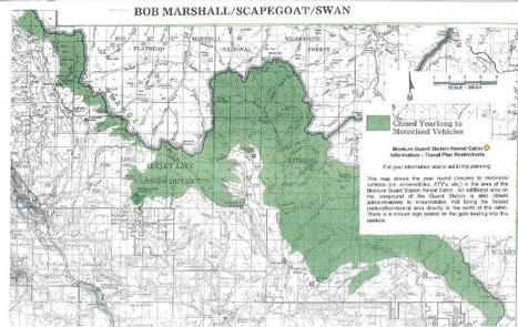
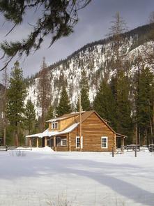
Monture Guard Station sits in the Lolo National Forest in western Montana, offering excellent winter recreation for visitors.
Recreation
Monture Guard Station offers modern amenities and furnishings just like home, but it also provides access to a variety of outdoor winter recreation opportunities that can only be enjoyed in a National Forest. A system of groomed trails surrounds the cabin and the nearby Seeley Lake, leaving lots of land for exploration.
The area also offers plentiful opportunities for cross country skiing, snowshoeing and snowmobiling.
Facilities
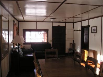
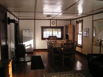
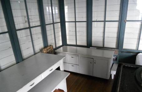
The two-story cabin is fully furnished and can accommodate up to eight people. Beds with mattresses are available on the second floor, while the first floor contains the kitchen, dining room and living room areas. A vault toilet outhouse is located approximately 75 yards northeast of the cabin.
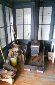
The kitchen is equipped with a propane stove and oven, a small microwave, refrigerator and a variety of cooking and eating dishes and utensils, as well as pots and pans. There is a large table and ten chairs, as well as couches and other seating. The living space has electricity, rugs and wood floors throughout. Heat is provided by a propane heater. Propane fuel is provided.
Guests should bring their own bedding, towels, food, water, garbage bags, toilet paper and other necessities. Cleaning supplies and equipment are provided and guests will need to clean the cabin prior to leaving.
The cabin is only available in the winter and guests will need to hike, snowmobile or ski about a mile to the cabin. Guests are responsible for their own travel arrangements and safety, and must bring several of their own amenities.
Natural Features
The cabin is located about 8 miles north of the town of Ovando at an elevation of 4,200 feet. The surrounding forest contains a wide variety of trees, plants and wildlife. The area is home to mountain goats, bighorn sheep, elk, moose, deer and grizzly and black bears. Both the bald and golden eagle reside in the forest, along with trumpeter swan, herons and dozens of varieties of ducks.
Nearby Attractions
The nearest gas and groceries is available about 10 miles from the cabin.
Nearby Activities
Camping
Winter sports
Wildlife viewing
Gallery
Directions
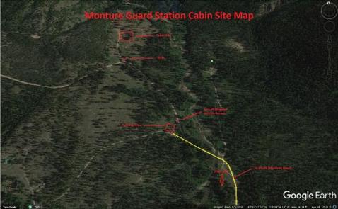
From Clearwater Junction (Highway 83 and Highway 200), travel east on Highway 200 for about 13 miles. Turn north on Forest Service Road 89 and continue for 8 miles. Cross the bridge over Monture Creek and proceed, veering slightly to the left for about 100 yards, to a small parking area. Maps are available online or for purchase by calling the Seeley Lake Ranger District.
The total distance from the parking area to the cabin is approximately a mile. The winter entrance to the cabin is on the rear (east side) of the cabin.
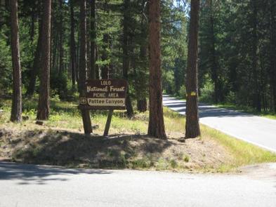
The Pattee Canyon Picnic Area offers family picnic sites available for free, along with three group picnic sites available by reservation. The picnic area is open July 1 through Labor Day.
Recreation
The Pattee Canyon Recreation Area is a popular spot for day hikes, mountain biking, horseback riding and picnicking. There are several trailheads in the area. Cross-country skiing is popular in the area during winter months.
Facilities
The picnic area offers several individual- and group-sized picnic sites. The roads are paved and the group sites have trash collection receptacles and accessible vault toilets. Drinking water is not available at the picnic area. A host may be on-site during summer months.
Natural Features
Set in a wooded canyon east of Missoula, at 4,100 feet, the picnic site is pleasantly shaded by large ponderosa pine trees.
Nearby Attractions
Pattee Canyon Picnic Area is located four miles southeast of Missoula.
Nearby Activities
Biking
Camping
Hiking
Winter sports
Wildlife viewing
Gallery
Directions
From I-90 in Missoula, take the Orange Street exit #104 and travel south. Turn left onto West Front Street and go 0.2 miles to South Higgins Avenue, then turn right. Continue on South Higgins Avenue for about 2.7 miles to Pattee Canyon Road, then turn left. On Pattee Canyon Road, travel 4 miles heading (east) up the canyon. Look for the Pattee Canyon Picnic Area sign and entrance.
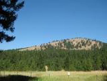
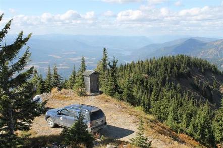
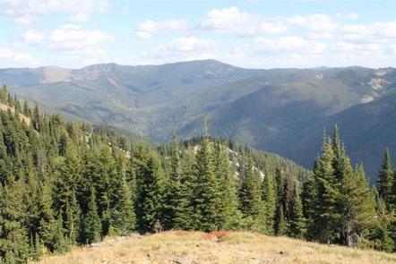
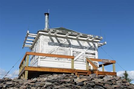
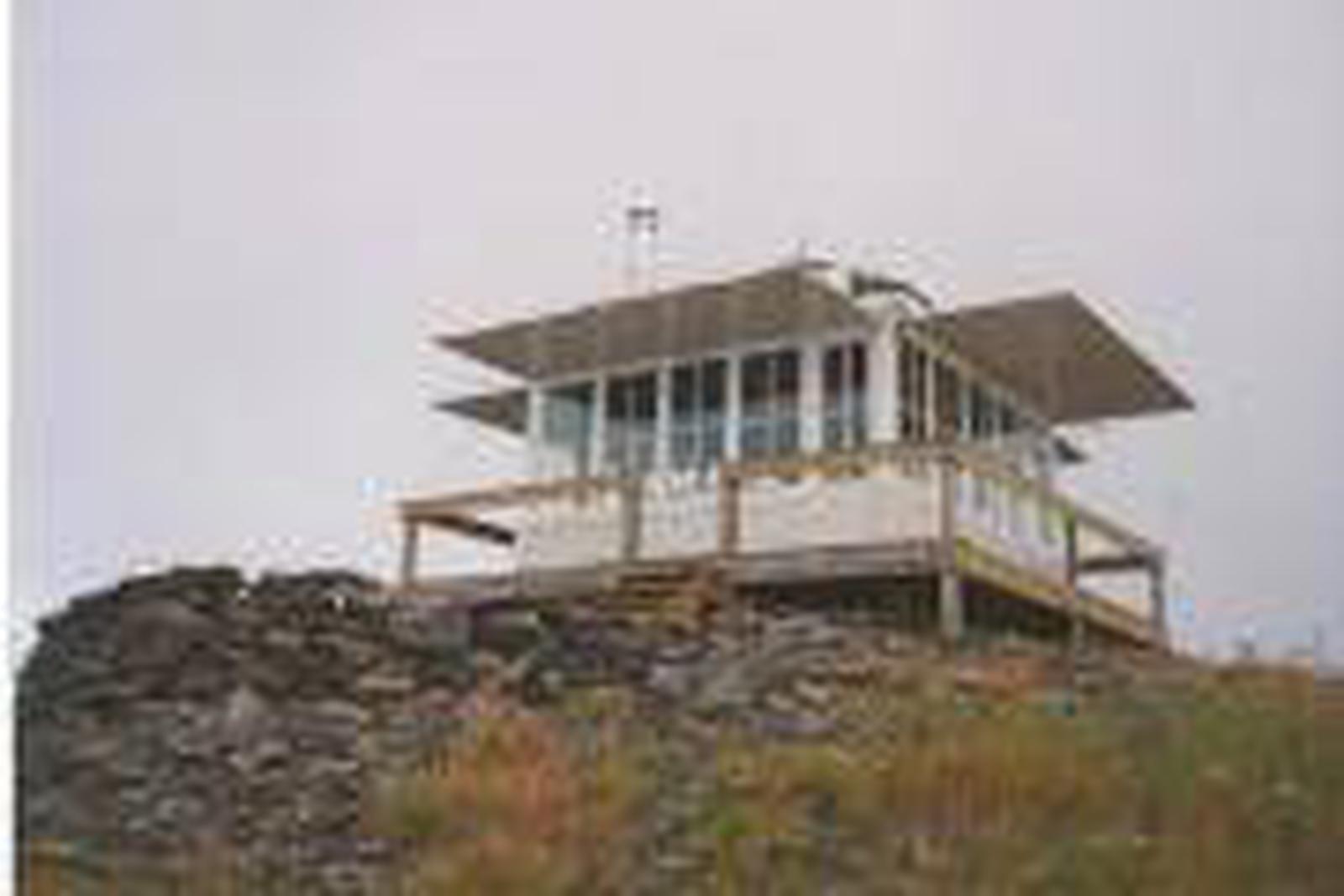
The Cougar Peak Lookout offers guests an opportunity to experience an old-time Forest Service lookout. The tower commands an impressive view of the river valley, the surrounding Cabinet Mountains and the opposing Coeur d’Alene Mountains. The structure is small and is not elevated like many other lookouts, and is available for rent from June 20 to September 18 each year.
The lookout can be accessed by vehicle, although late spring snow drifts may compromise parts of the road, requiring visitors to hike a short distance. Guests are responsible for their own travel arrangements and safety, and must bring several of their own amenities.
Recreation
A variety of trails and points of exploration are accessible from the lookout. The Cougar Peak Trail follows the ridge below the lookout and travels towards Vermillion Pass to the northeast.
The Clark Fork River is dammed twice within an hour drive of the lookout. The Noxon Rapids and the Cabinet Gorge dams create reservoirs that have become popular spots for boating and fishing for large and smallmouth bass, as well as northern pike.
Facilities
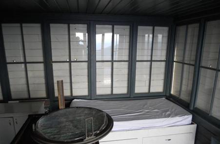
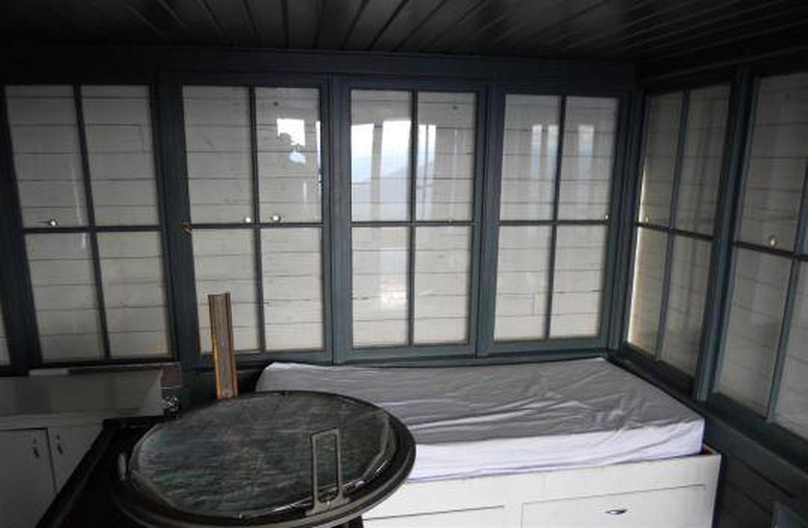
The 14-by-14 structure is small, but can accommodate up to four people. There is a full bed for two with a mattress pad, a table with two chairs, and a wood stove. No other furnishings are provided. A rustic outhouse with a vault toilet is available about 200 feet from the lookout, at the parking area.
Guests will need to bring water for drinking, cooking and cleaning purposes, as well as their own bedding and cots for additional sleeping options, cooking and eating equipment and fuel, cooking and eating utensils, flashlights, matches and toilet paper, among other necessities. There is no water available at the site. There is room for a small tent outside the tower.
Guests should be prepared for cold and often wet or damp weather, even if the weather in the valley is warm and dry. Food, garbage and other waste needs to be put away at all times to avoid attracting bears. Firewood may be collected locally for the wood stove.
Natural Features
The tower is situated in the Clark Fork River drainage, at an elevation of 6,694 feet, in the Cabinet Mountains of western Montana. It was built in 1952 to replace an existing, older structure dating back to the 1930s. The lookout was part of the old Cabinet National Forest, which was divided by the Forest Service in 1954 to become the Lolo National Forest.
The 2 million-acre forest includes four wilderness areas and a wide variety of trees, plants and wildlife. The area is home to mountain goats, bighorn sheep, elk, moose, deer and grizzly and black bears (learn more about bear safety). Both the bald and golden eagle reside in the forest, along with trumpeter swan, herons and dozens of varieties of ducks.
Nearby Activities
Biking
Camping
Fishing
Hiking
Wildlife viewing
Gallery
Directions
From Thompson Falls, Montana, travel west on Highway 200 for about a mile. Before crossing the Clark Fork River bridge, turn right onto Blue Slide Road and continue about 8 miles, to the junction with Forest Road 403. Turn right and travel about 14 miles to the lookout. Maps are available online or for purchase by calling the Plains/Thompson Falls Ranger District.
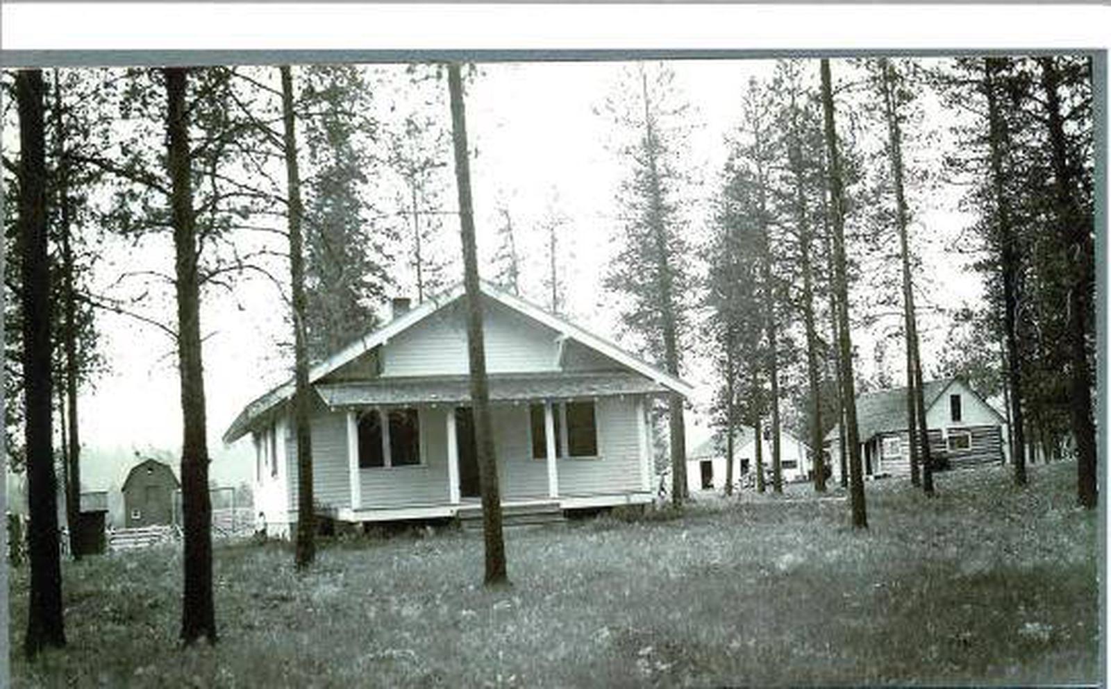
The Bend Guard Station is located in a historic site within the Lolo National Forest of northwestern Montana. It is equipped with modern features, including a full-service kitchen and bathrooms, and provides guests with access to a variety of activities.
The cabin sits within an open meadow surrounded by an evergreen forest, providing beautiful scenery during any season.
Recreation
The Bend area offers opportunities for a variety of outdoor recreation experiences, including hiking, fishing, mountain biking, cross country skiing, snowshoeing and berry picking. A variety of trails snake around the campground and through the forest, several of which are accessible near the cabin.
The Thompson River is a short walk from the cabin. Anglers might see a variety of trout as well as mountain whitefish in the river.
Facilities
The two-story cabin has four bedrooms, two bathrooms, a large kitchen and a living area. Beds with mattresses can sleep up to 16 people. It has electric heaters, flush toilets, hot showers and a fully furnished kitchen, with modern appliances including a two electric stoves, a microwave, two refrigerators and two sinks with running hot and cold water. Basic cooking and eating utensils are also supplied.
Guests will need to bring their own bedding, food, toilet paper and garbage bags. The cabin will need to be cleaned before leaving and basic cleaning equipment is provided.
The cabin is available to rent year-round, except for the month of May, when it is reserved for administrative and educational uses. A key code will be provided after a reservation is made. The key code gives you access to the entry gate and a lock box, which holds the key to unlock the cabin. Please make sure to return the key to the lock box before leaving the facility.
Natural Features
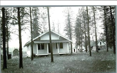
The 3,200-foot elevation site has multiple structures and has previously been used as a ranger station for the old Cabinet National Forest, which was divided by the Forest Service in 1954. The original log cabin is on-site and was constructed in 1911.
While there are several buildings at Bend, the only one available for recreation rental use is the combined bunkhouse and cookhouse building. It was built in 1923 to house Forest Service work crews and rangers working in the area and was remodeled in 1984.
The 2 million-acre forest includes four wilderness areas and a wide variety of trees, plants and wildlife. The area is home to mountain goats, bighorn sheep, elk, moose, deer and grizzly and black bears. Both the bald and golden eagle reside in the forest, along with trumpeter swan, herons and dozens of varieties of duck.
The cabin is accessible by vehicle, but requires high-clearance with tire chains during winter months. The roads leading to the cabin may not be plowed on a regular basis in the winter. Four-wheel drive is highly recommended. There is no cell phone service or a land line at Bend. The nearest cell phone service is a few miles away. Guests are responsible for their own travel arrangements and safety, and must bring several of their own amenities.
Nearby Attractions
Fishing and water sports are available at Thompson and McGregor Lakes, both of which are a 30-minute drive from the cabin.
Nearby Activities
Biking
Historic & cultural site
Camping
Fishing
Hiking
Hunting
Winter sports
Wildlife viewing
Gallery
Directions
This rental is located approximately 32 miles up the Thompson River Road (County Road 56 on maps, County Road 556 on the ground) from its junction with Montana Highway 200, five miles east of Thompson Falls, Montana. It may also be accessed from U.S. Highway 2 by turning south on the Thompson River Road (County Road 56 on maps, County Road 556 on the ground) between McGregor Lake and Lower Thompson Lake, approximately 40 miles west of Kalispell, Montana. After leaving Highway 2 or 200, area roads are low standard gravel or dirt and are often rough. Area roads also serve logging trucks and should be driven with care. During the winter, it may be necessary to hike, ski or snowmobile for at least a mile to the cabin, as roads are not always plowed. Maps are available online or for purchase by calling the Plains/Thompson Falls Ranger District.