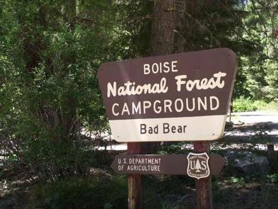
Categories
Uncategorized

GRAHAM CABIN

Overview

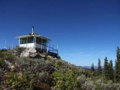
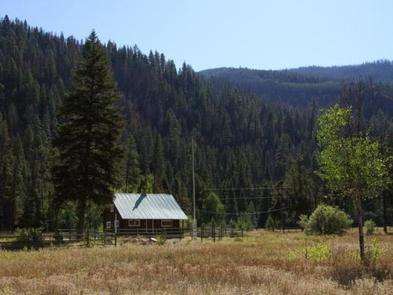
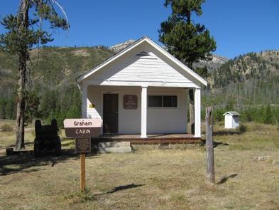
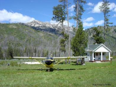
Graham Cabin, a former Forest Service Guard Station, is an ideal getaway for motorcyclists, flight enthusiasts and equestrians, for whom getting there is half the fun. An airstrip is just across from the cabin for guests who want to fly in, and the surrounding terrain is ideal for traversing on foot, horseback or motorcycle.

Guests to the cabin will find a few amenities but may need to bring some additional supplies and gear to make their stay comfortable. The beauty of the surrounding landscape and the abundance of recreational activities provice a relaxing and enjoyable experience.

Recreation

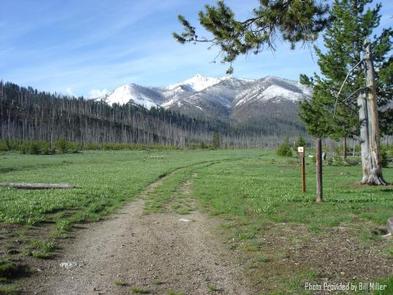
Several trails located within 2 miles of the cabin offer superb horseback riding opportunities, including the nearby Horse Heaven Trail. These trails are in varying stages of maintenance, but tend to be in good condition for at least 2 miles. Hikers can follow the river all the way to its headwaters in the Sawtooth Wilderness. Motorcyclists can ride the nearby roads.

Fishing is good in the river and nearby Johnson Creek. Big game hunting is a popular activity in season.

Facilities

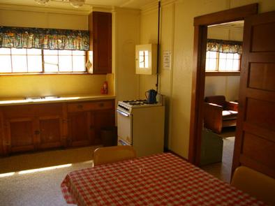
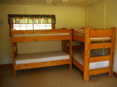
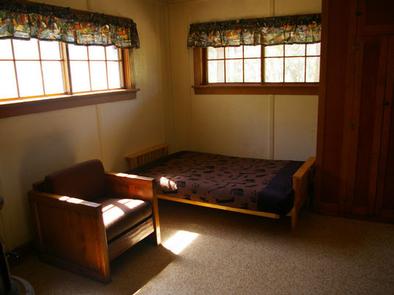
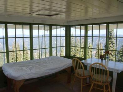
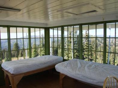
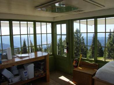
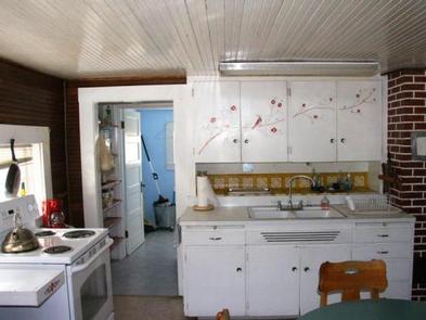
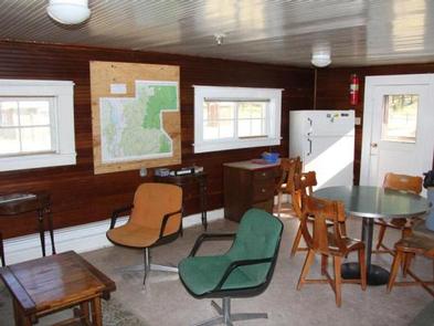
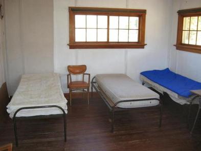
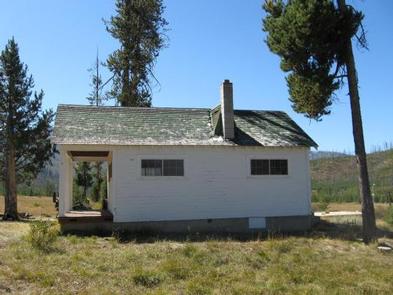
Graham Cabin can accommodate a maximum of six people on twin beds with mattresses. Other furnishings include a table with chairs. The kitchen has a wood stove for cooking and heating, as well as a sink with running, non-potable water. This water is only available from approximately July 15 through September 1.

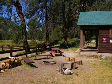
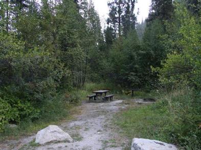
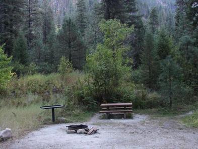
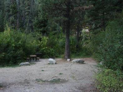
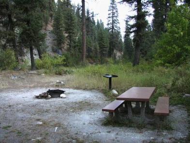
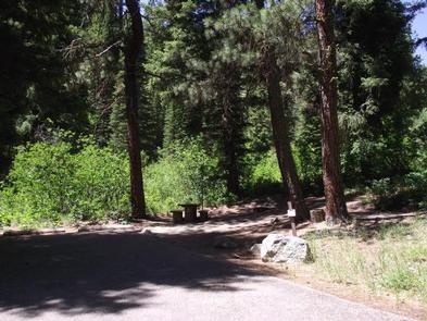
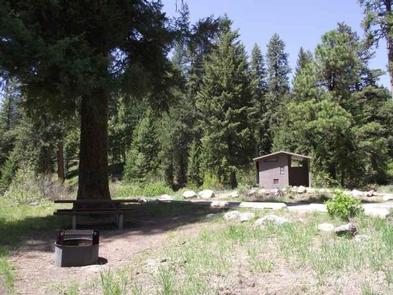
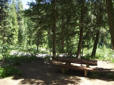
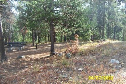
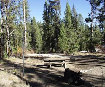
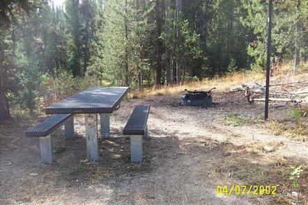
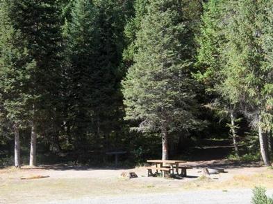
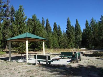
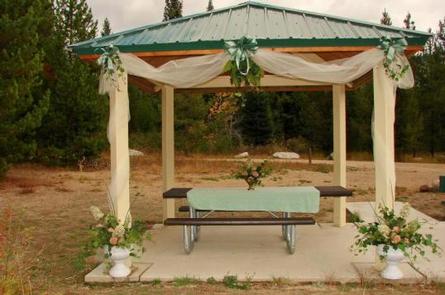
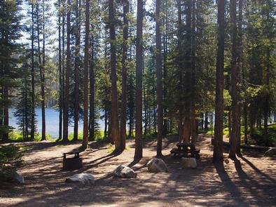
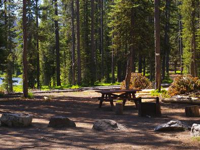
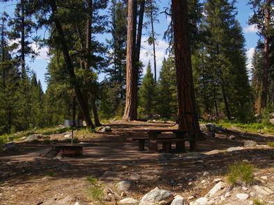
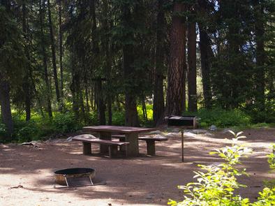
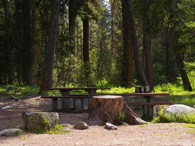
An outhouse with vault toilet sits behind the cabin. A picnic table and campfire ring are located just outside. The front porch invites guests to relax and admire the view.

This rustic two-room cabin has no potable water or electricity. Guests need to provide their own drinking water or bring a water filter. Bedding, lighting, cookware, kitchen utensils, matches and first aid supplies are not provided. A supply of firewood may be needed.

Natural Features

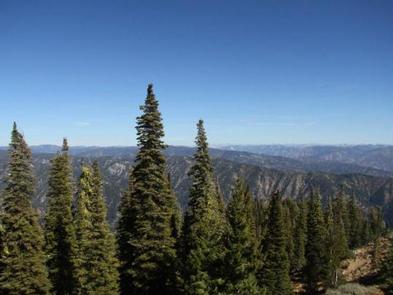
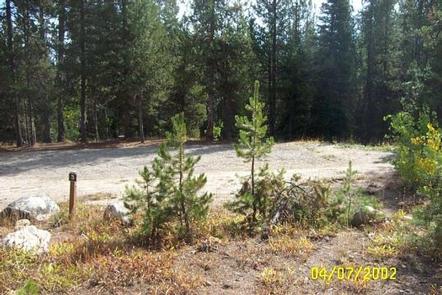
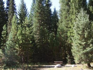
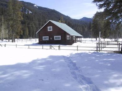
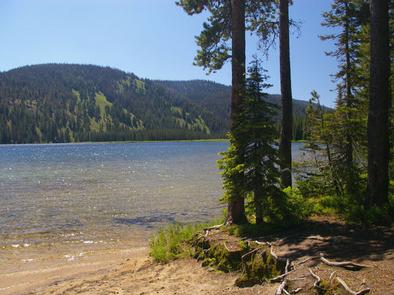
Graham Cabin is located on the North Fork Boise River, adjacent to the Sawtooth Wilderness at an elevation of 5,720 feet. The dwelling sits in an open grassy area surrounded by the rugged mountain peaks of the Sawtooth Range, which are dotted with evergreens. The surrounding area still exhibits some signs of a past forest fire.

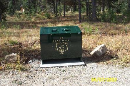
Wildlife watchers may spot elk, deer, mountain goats, wolves, coyotes, cougars, bobcats and bears. The occasional wolverine may also be seen, as their numbers are growing within the Sawtooth Wilderness.

Nearby Activities

  • Biking
  • Camping
  • Fishing
  • Hiking
  • Horseback riding
  • Hunting
  • Wildlife viewing

Gallery

Directions

Graham Cabin is 53 miles northeast of Idaho City. From Idaho City, take Highway 21 for 18 miles to Crooked River-Little Owl Road #384. Turn left and stay on Road #384
for 4 miles to Pikes Fork Road #312. Turn right and stay on Road #312 for 26 miles. There are only 2 major road intersections on Road #312; just keep bearing right and
follow the directional signs.

Vehicle access to the area is generally limited from mid-July to the beginning of October due to high elevation snow. The road is extremely rocky and rutted and has
steep sections; you also have to ford the river. Only high clearance 4-wheel drive vehicles are recommended. Plan on a minimum 3-hour trip from Idaho City to the cabin.

Guests arriving on horseback can either ride horses the last 10 miles of Road #312 or ride the 6-mile Horse Heaven Trail from Road # 327 (just beyond Deer Park).

GPS Coordinates

Latitude 43° 57′ 25.9999″ N

Longitude 115° 16′ 32.9999″ W

Categories
Uncategorized

DEER PARK CABIN

Overview

This site was originally established as Deer Park Ranger Guard Station in 1913, and a cabin was built here in 1917. This cabin, along with many others in Boise National Forest, was replaced in the 1930s by the Civilian Conservation Corps. Deer Park Cabin looks much the same today as it did in the 1930s.

The cabin is available from mid-May through late September, and it’s easily accessible by car in good weather. Many creature comforts are provided, but guests may need to bring additional gear and supplies to have a comfortable and enjoyable stay.

Recreation

The North Fork Boise River Trail, which begins directly behind the cabin, leads hikers upstream. The 5-mile trail passes through some of the roughest, most scenic canyon walls in Idaho before dipping down to the river’s edge to pass by a rock bluff.

Horse Heaven Trail begins about a mile from the cabin and connects with the Swanholm/Warrior Trails. All these trails are open to hikers, horseback riders, mountain bikers, dirt bikers and motorcyclists, although some of the sections of the trail may be particularly difficult for motorcycles. Click here for an Idaho OHV Safety Message.

The river flows across the road from the cabin, offering good rainbow trout fishing after about July 1st. Big game hunting is also a popular pastime in the area.

Facilities

The cabin accommodates six people on a futon and two sets of bunkbeds with mattresses. The kitchen is equipped with a table and chairs, propane stove, cookware, dishes, utensils and a dry sink. Garbage collection is provided.

A vault toilet outhouse is just outside. A shed to the right of the cabin houses a hand pump for potable water. A picnic table and campfire ring are located out front.

The cabin has no indoor plumbing or electricity. Bedding, pillows, lighting and emergency supplies are not provided.

Natural Features

Deer Park Cabin is located in an open meadow lined with mature Ponderosa pines at an approximate elevation of 4,400 feet. Nearby, the North Fork Boise River rushes over rocks and through jagged granite walls studded with pine trees.

Wildlife watchers may want to look for deer and elk. Bears are occasional visitors to the area as well. A variety of waterfowl are attracted to the river, as well as bald eagles and osprey.

Nearby Activities

  • Biking
  • Camping
  • Fishing
  • Hiking
  • Hunting
  • Wildlife viewing

Gallery

Directions

From Idaho City, take State Highway 21 for 18 miles to Crooked River/Little Owl Road #384. Turn right and stay on Road #384 for 13.5 miles to North Fork Boise River Road #327. Turn left on Road #327 and drive upstream for 5 miles to Hunter Creek Road #348. Go straight ahead on Road #348 for 1/4 mile where you will see a meadow in front of you and a lower standard road turning off to the right. This road will lead you to Deer Park Cabin, about 300 yards in.

GPS Coordinates

Latitude 43° 55′ 32.0002″ N

Longitude 115° 24′ 2.9999″ W

Categories
Uncategorized

RATTLESNAKE

Overview

Rattlesnake Campground is located 13 miles north of Crouch, Idaho along the Middle Fork Payette River at an elevation of 3621 feet.
The Middle Fork drainage offers a variety of excellent trails. Fishing and hunting are popular activities as well.

Recreation

The Middle Fork Payette River offers good to excellent fishing most of the year. Anglers cast for whitefish and rainbow trout.

Many trails for hiking, mountain biking, horseback and ATV riding can be found in the area. The One Spoon Trail, Rattlesnake Trail, and 465 ATV Trail are all in the vicinity of the campground.

In-season big game hunting for deer, elk and bear is a popular activity in the surrounding mountains.

Facilities

The campground can be reserved as one large, accessible group site, which consists of nine single sites and one double site. This group site can accommodate up to 100 people. A two night minimum stay is required on weekends. A three night minimum stay is required on holiday weekends.
Picnic and utility tables, campfire rings and a picnic shelter are provided. Two accessible vault toilets are also provided. Ten parking spurs are available, each 50-75′ in length.

Additional camping is available at nearby Hardscrabble and Trail Creek Campgrounds.

Natural Features

The campground is situated on the banks of the Middle Fork Payette River among Douglas fir and lodgepole pine trees, which offer partial shade. A few sites offer river views through the dense vegetation on the banks.

A variety of wildlife makes its home in the Middle Fork drainage, including deer, elk, and red-tailed hawks.

Nearby Activities

  • Biking
  • Camping
  • Fishing
  • Hiking
  • Hunting
  • Picnicking

Gallery

Directions

From Crouch, travel north on Forest Road 698 approximately 14 miles to the campground, which is located on the left-hand side of the road.

GPS Coordinates

Latitude 44° 15′ 57.3502″ N

Longitude 115° 52′ 48.0698″ W

Categories
Uncategorized

DEADWOOD LOOKOUT REC CABIN

Overview

Deadwood Lookout Recreation Cabin is a historic Forest Service fire lookout on Deadwood Mountain. The structure provides sweeping panoramic views of the surrounding forest, making this a unique place to overnight.

At least two other lookouts have existed previously on Deadwood Mountain, but the current one was built in 1934 by the Civilian Conservation Corps. It was actively used as a fire lookout until 1972. It has since become one of the most popular rental cabins in Idaho.

The peak season is late June through mid-October. Guests can drive to the cabin, but high clearance vehicles are recommended for the dirt access road because it is narrow, steep and winding.

The cabin offers only a few basic amenities. Guests should be prepared to bring most of what they need to make themselves comfortable, but the views of the mountains by day and the stars at night guarantee a memorable and rewarding experience.
 

Recreation

Hikers and mountain bikers have access to three nearby trails: Scott Mountain, Julie Creek, and Nellie’s Basin. The Deadwood Ridge Trail is a popular destination for equestrians, hikers, mountain bikers, and off-road vehicle enthusiasts.  

Facilities

This rustic cabin is a 14×14-ft. room equipped with two single beds with mattresses that can be fastened together. A wood stove is available for heating and cooking. A wood counter with shelf and a table with two chairs complete the furnishings. A vault toilet, picnic table, and campfire ring are located outside and below the lookout. The cabin is surrounded by an exterior catwalk.

No water, electricity or firewood is available. Guests must bring their own water supply, as well as trash bags to pack out garbage. Bedding, pillows, cookware, kitchen utensils, and tableware are not provided.

Guests are expected to clean the lookout before leaving. A broom and dustpan are provided for this purpose.

Natural Features

The cabin is perched atop Deadwood Mountain at an elevation of 7482 feet. A variety of colorful wildflowers bloom around the base of the cabin in the summer, and stands of conifers dot the landscape.

Mornings bring unobstructed views of sunrises. Guests can watch the sun set each evening and then gaze out at an endless canopy of stars.

Wildlife enthusiasts may spot elk, deer and bear in the surrounding area. Bull moose have occasionally been spotted along nearby trails. Guests may find swallows and other birds nesting just outside the lookout.

Guests can also expect to see various types of snakes, including Gopher snakes, Garter snakes, Racer snakes, Bull snakes & Rattlesnakes, especially when temperatures reach 70-82 degrees fahrenheit outside.

Nearby Activities

  • Biking
  • Camping
  • Hiking
  • Wildlife viewing

Gallery

Directions

From Boise, Idaho, take Highway 55 north about 35 miles to Banks, Idaho.
Turn right (east) on Banks-Lowman Road and proceed 25 miles to the
junction with Forest Road 555. Turn left (north) on Road 555 and proceed
9 miles to the junction of Forest Roads 555 and 555EC. Turn right on 555EC
and proceed 3 miles to Deadwood Lookout Recreation Cabin at the end of the
road.

GPS Coordinates

Latitude 44° 6′ 32.0000″ N

Longitude 115° 42′ 11.9999″ W

Categories
Uncategorized

BAD BEAR CAMPGROUND

Overview

Bad Bear Campground is located 48 miles northeast of Boise, Idaho, in a scenic Ponderosa pine forest along Highway 21 at an elevation of 5,100 feet. Wildlife and summer wildflowers are abundant. Historic Idaho City is just 11 miles south. Mores Creek runs adjacent to the site, offering whitefish and rainbow trout fishing.

Highway 21, also known as the Ponderosa Pine Scenic Byway, snakes along Mores Creek to Mores Creek Summit, Gold Fork, and Banner Ridge with breathtaking views of the surrounding mountains and forest.

Recreation

Numerous trail opportunities are in the area, offering hiking, biking, horseback riding, and ATVing. In winter, the area becomes a playground for backcountry skiers and snowmobilers.

Facilities

This campground contains 6 sites that can accommodate up to 6 people each. Picnic tables, a charcoal BBQ grill, and fire ring with benches are profided. The site is in an open area with shade. Vault toilets and garbage service are provided. Parking spurs are paved. Due to its proximity to the highway, some noise from passing traffic is to be expected.

Nearby Attractions

Nearby Activities

  • Camping
  • Fishing
  • Visitor center
  • Wildlife viewing

Gallery

Directions

Hayfork Group Cg (ID)
HIGHWAY 21
Idaho City ID 83706

GPS Coordinates

Latitude 43° 54′ 31.0000″ N

Longitude 115° 41′ 47.0000″ W

Categories
Uncategorized

EDNA CREEK CAMPGROUND

Overview

Edna Campground is located 56 miles northeast of Boise, Idaho, in a scenic Ponderosa pine forest along Highway 21 at an elevation of 5,700 feet. Wildlife and summer wildflowers are abundant. Historic Idaho City is just 11 miles south. Crooked River runs near the site, offering whitefish and rainbow trout fishing.

This campground contains 9 site that can accommodate up to 6 people each. Picnic tables, a BBQ grill, and fire ring with benches are provided. The site is in an open area with shade. Vault toilets and garbage service are provided. Parking spurs are graveled. Due to its proximity to the highway, some noise from passing traffic is to be expected.

Highway 21, also known as the Ponderosa Pine Scenic Byway, snakes along Mores Creek to Mores Creek Summit, Gold Fork, and Banner Ridge with breathtaking views of the surrounding mountains and forest. Numerous trail opportunities are in the area, offering hiking, biking, horseback riding, and ATVing. In winter, the area becomes a playground for backcountry skiers and snowmobilers.

Nearby Activities

  • Camping
  • Fishing
  • Visitor center
  • Wildlife viewing

Gallery

Directions

Hayfork Group Cg (ID)
HIGHWAY 21
Idaho City ID 83706

GPS Coordinates

Latitude 43° 54′ 31.0000″ N

Longitude 115° 41′ 47.0000″ W

Categories
Uncategorized

PEACE VALLEY CAMPGROUND

Overview

Peace Valley Campground sits just 27 miles north of Garden Valley, Idaho, at an elevation of 4591 feet. The beautiful Peace Valley offers excellent hiking, motorcycle riding, fishing, and hunting opportunities.

Recreation

Peace Valley offers several trails for hiking, mountain biking, horseback riding, and OHV use. Peace Creek Trail and Bitter Creek Trail (both motorcycle trails) begin nearby. The Rattlesnake Trail and 465 ATV Trail are in the vicinity of the campground.

Peace Creek and nearby Silver Creek offer excellent fishing most of the year. Anglers cast for whitefish and rainbow trout.

In-season big game hunting for deer, elk, and bear is a popular activity in the surrounding mountains.

Facilities

This fully-accessible campground is a small facility with just five campsites that make up one group site that can accommodate up to 50 people. Picnic tables, grills, a small picnic shelter, and campfire rings are provided. Parking spurs can accommodate small to medium RVs up to 30 feet in length. Vault toilets and drinking water are available.

Natural Features

The surrounding area consists of high, forested mountains, and steep valleys. The campground lies close to an experimental forest and a fire lookout.

A variety of wildlife makes its home in and around Peace Valley, including deer, elk, bald eagles, and red-tailed hawks.

Nearby Attractions

Silver Creek Plunge, a privately-developed hot springs resort, is 2.5 miles away with a hot springs pool, general store, concessions, a playground, horseshoe pits, and both volleyball and basketball courts.

Nearby Activities

  • Biking
  • Camping
  • Hiking
  • Hunting
  • Swimming site

Gallery

Directions

From Garden Valley, Idaho, take Forest Road 698 north approximately 16 miles north. Turn right at the junction of FR 698 and FR 671. Take FR 671 for about 10 miles to the campground, which is on the left-hand side of the road.

GPS Coordinates

Latitude 44° 21′ 14.0000″ N

Longitude 115° 46′ 58.0001″ W

Categories
Uncategorized

JOHNSON CREEK GUARD STATION

Overview

Johnson Creek Guard Station was built in 1922 and offers a charming mountain respite with modern conveniences. The cabin offers nearly everything needed for a pleasant and comfortable stay.

Peak season for the cabin is typically early June through late September. It can be accessed by most vehicles via dirt and gravel roads, but trailers are not
recommended.

Recreation

The cabin is near several trailheads into the Frank Church – River of No Return Wilderness. These non-motorized trails are popular for hikers, mountain bikers and equestrians. Off-road vehicle trails are also nearby. Click here for an Idaho OHV safety message.

The South Fork Salmon River and Johnson Creek offer opportunities for fishing. Berry picking and hunting are popular pastimes in season.

Facilities

The rustic cabin has two twin beds with mattresses in the loft, as well as two cots, a couch and a heater. A full size bed is in separate bedroom.  The kitchen is equipped with a table and four chairs, an electric range and a refrigerator. Cookware and utensils are provided, including saucepans, pots and lids, plates, bowls, cups, mugs, utensils, knives, a cutting board, salad bowl and cookie sheet.

A modern bathroom with a flush toilet and shower is available. Two picnic tables, a campfire ring and two grills are located outside behind the cabin.

Guests must bring garbage bags to pack out their own trash. Bedding, lanterns or flashlights, towels and emergency drinking water are not provided.

Natural Features

Johnson Creek sits in a pretty mountain meadow a stone’s throw from scenic Johnson Creek, a tributary of the South Fork Salmon River. Mountain slopes covered in dense pine forest surround the cabin.

Wildlife watchers may see deer, elk, bear and moose. Bald eagles are often spotted soaring overhead.

Nearby Attractions

The tiny community of Yellow Pine is a few miles north of the cabin and offers limited services. The popular Yellow Pine Music & Harmonica Festival is held annually in August.

Nearby Activities

  • Biking
  • Historic & cultural site
  • Camping
  • Fishing
  • Hiking
  • Hunting
  • Wildlife viewing

Gallery

Directions

From Cascade, ID, head north on ID-55/Main Street toward McCall, ID. Turn right/east on FH-22/Warm Lake Road. Stay on this road for about 35 miles. Turn left/north on Road 413/Johnson Creek Road. Stay on this road for about 22 miles. The cabin sits on the right/east side of the road. Look for the Forest Service sign.

This is good unpaved road, but there are a few narrow and steep sections with few pull-outs, and there may be some washboard sections. Use low gears. Some sections
of the road are steep.

For additional information, the Cascade District Office is located in Cascade on the north end of town off Highway 55 on the right side of the road.
Office hours are Monday-Friday 8 a.m. to 4:30 p.m., closed on federal holidays. Please call the office at (208) 382-7400 for information on alternate routes.

GPS Coordinates

Latitude 44° 55′ 41.0002″ N

Longitude 115° 28′ 39.0000″ W

Categories
Uncategorized

BULL TROUT

Overview

Bull Trout Campground is located on the shores of beautiful Bull Trout Lake at an elevation of 6,900 feet. The lake offers great fishing and canoeing opportunities. Many trails for hiking, biking, horseback and off-road vehicle riding are in the area.

Recreation

Bull Trout Lake offers excellent canoeing and kayaking opportunities, as the lake is for non-motorized watercraft only. Anglers fish for brook and rainbow trout. A primitive boat ramp is located on the west side of the lake.

Martin Lake is nearby, offering canoeing and fishing. The lake is stocked with rainbow trout.

Many miles of trails can be found in the area, including the 11-mile Warm Spring Trail for hikers. The 35-mile Kirkham Ridge Trail is open to hiking, mountain biking, horseback riding and dirt biking.

Facilities

This campground contains group, equestrian and single and double campsites, many of which are accessible. The group sites can accommodate up to 50 people each. Equestrian sites each contain a corral and large parking spur. Some sites are on the waterfront and have direct lake access, others have lake views.

Vault toilets, drinking water and trash collection are provided. Roads and parking spurs within the campground are dirt. A campground host is on-site.

Natural Features

The campground is situated in a mixed-growth forest of Douglas fir and lodgepole pine, which offers partial shade. Summer wildflowers are abundant.

Nearby Activities

  • Biking
  • Boating
  • Historic & cultural site
  • Camping
  • Fishing
  • Hiking
  • Hunting
  • Wildlife viewing

Gallery

Directions

From Boise, Idaho, take State Street to Highway 55 north. At Banks, take Highway 17/Banks-Lowman Highway to Lowman. Take Highway 21 east to milepost 107. Turn left on Forest Road 520. Proceed on dirt road 2 miles to the campground.

GPS Coordinates

Latitude 44° 17′ 52.8299″ N

Longitude 115° 15′ 19.8601″ W

Categories
Uncategorized

WARM LAKE

Overview

Warm Lake Campground is near the eastern shore of beautiful Warm Lake, at an elevation of 5,300 feet. Visitors enjoy boating, fishing, swimming, hiking and viewing local wildlife.

Recreation

Warm Lake offers great fishing opportunities for cutthroat, rainbow, lake and bull trout. Boating, canoeing and swimming are popular activities. A developed swim beach is available less than a quarter-mile away, at Warm Lake Lodge.

Billy Rice Swim Beach is just over a mile from the campground, on the north side of the lake. The area offers a day-use site for picnicking and swimming. A boat ramp is located at nearby Shoreline Campground.

The surrounding area offers great hiking, mountain biking, horseback and off-road vehicle riding, and hunting. The WeWuKiye (Wa Wu Kia) Trail No. 252 was recently built and can be accessed at Shoreline Campground. It is popular for hiking and mountain biking.

For off-road vehicle enthusiasts, Telephone Ridge Trail No. 112 offers 20 miles of trails for all riding levels, with staging areas within the campground and up the road at Shoreline Campground.

Facilities

This small campground provides campsites equipped with a picnic table, campfire ring and grill. Vault toilets, drinking water and trash collection are provided at the campground, but electricity is not available.

Roads and parking spurs within the facility are gravel. The lake is not visible from the campground.

Natural Features

The campground is situated in a scenic forest of towering, old-growth ponderosa pine, which provides partial shade in the campground. Chipmunk Creek runs alongside the campground. Summer wildflowers are abundant.

A variety of wildlife including bears, deer, elk, fox, grouse, eagles, osprey, grosbeaks, whooping cranes and otters, lives around the lake.

Nearby Attractions

Warm Lake Lodge is located across the road from the campground and has a restaurant and small store with camping and fishing essentials.

Nearby Activities

  • Biking
  • Boating
  • Camping
  • Fishing
  • Hiking
  • Wildlife viewing
  • Swimming site

Gallery

Directions

From Boise, Idaho, travel 85 miles north on Highway 55 to Cascade. Turn east on Warm Lake Highway and travel 25 miles to Forest Road 579KA. Turn south and travel a short distance to the campground.

GPS Coordinates

Latitude 44° 39′ 7.9999″ N

Longitude 115° 39′ 20.0002″ W